Lousa
Airport details
| Country | Portugal |
| State | Coimbra District |
| Region | LP |
| Airspace | Lisbon Ctr |
| Municipality | Lousã e Vilarinho |
| Elevation | 651ft (198m) |
| Timezone | GMT +0 |
| Coordinates | 40.14379, -8.24159 |
| Magnetic var | |
| Type | land |
| Available since | X-Plane v10.40 |
| ICAO code | LPLZ |
| IATA code | n/a |
| FAA code | n/a |
Communication
| Lousa CTAF | 122.500 |
Nearby Points of Interest:
Palácio dos Salazares
-Santuário do Senhor da Serra
-Miranda do Corvo
-Góis
-Mata Nacional de Vale de Canas
-Seminário Maior de Coimbra
-Aqueduto de São Sebastião
-University of Coimbra General Library
-Faculdade de Letras da Universidade de Coimbra
-Paços da Universidade ou Paços das Escolas
-Jardim da Manga
-Igreja de São João das Donas
-Palácio dos Figueiredos
-Mosteiro de Folques, recheio artístico e quinta
-Casulo (Figueiró dos Vinhos)
-Igreja de São João Baptista (Figueiró dos Vinhos)
-Ançã
-Buçaco Forest
-Complexo Termal do Luso
-Igreja Matriz de São João de Areias
-Igreja Matriz de Santo Varão
-Antigo Convento do Desagravo do Santíssimo Sacramento
-Igreja Matriz de Treixedo
-Oleiros
-Capela da Misericórdia de Montemor-o-Velho
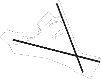
Runway info
Runway 17 / 35  | ||
| length | 520m (1706ft) | |
| bearing | 159° / 339° | |
| width | 10m (33ft) | |
| surface | asphalt | |
| Runway 11 / 29 | ||
| length | 636m (2087ft) | |
| bearing | 105° / 285° | |
| width | 10m (33ft) | |
| surface | asphalt | |
| displ threshold | 0m (0ft) / 58m (190ft) | |
Nearby beacons
| code | identifier | dist | bearing | frequency |
|---|---|---|---|---|
| FTM | FATIMA VOR/DME | 30.9 | 208° | 113.50 |
| MTR | MONTE REAL TACAN | 35.2 | 244° | 109.60 |
| NSA | NISA VOR/DME | 37.9 | 151° | 115.50 |
| VIS | VISEU VOR/DME | 38.4 | 32° | 113.10 |
| DAR | DME | 47.4 | 1° | 114.90 |
| OVR | OVAR TACAN | 48.2 | 332° | 110.60 |
Disclaimer
The information on this website is not for real aviation. Use this data with the X-Plane flight simulator only! Data taken with kind consent from X-Plane 12 source code and data files. Content is subject to change without notice.