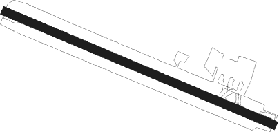
Vila Das Velas - Sao Jorge
Airport details
| Country | Portugal |
| State | Autonomous Region of Azores |
| Region | LP |
| Airspace | Santa Maria Oceanic Ctr |
| Municipality | Velas |
| Elevation | 333ft (101m) |
| Timezone | GMT -1 |
| Coordinates | 38.66523, -28.17469 |
| Magnetic var | |
| Type | land |
| Available since | X-Plane v10.40 |
| ICAO code | LPSJ |
| IATA code | SJZ |
| FAA code | n/a |
Communication
| Sao Jorge ATIS | 122.300 |
Runway info
| Runway 13 / 31 | ||
| length | 1559m (5115ft) | |
| bearing | 112° / 292° | |
| width | 45m (148ft) | |
| surface | asphalt | |
| displ threshold | 149m (489ft) / 146m (479ft) | |
Nearby beacons
| code | identifier | dist | bearing | frequency |
|---|---|---|---|---|
| VAP | SAO JORGE VOR/DME | 2 | 70° | 113 |
| PI | PICO NDB | 12.5 | 245° | 420 |
| VFL | HORTA VORTAC | 22.8 | 252° | 112.70 |
| DHT | DA GUIA DME | 23 | 252° | 113.60 |
| HT | HORTA NDB | 23 | 252° | 360 |
| FIL | HORTA NDB | 25.4 | 254° | 380 |
| GC | GRACIOSA NDB | 26.6 | 19° | 428 |
Disclaimer
The information on this website is not for real aviation. Use this data with the X-Plane flight simulator only! Data taken with kind consent from X-Plane 12 source code and data files. Content is subject to change without notice.
