Sintra
Airport details
| Country | Portugal |
| State | Lisbon District |
| Region | LP |
| Airspace | Lisbon Ctr |
| Municipality | Almargem do Bispo |
| Elevation | 438ft (134m) |
| Timezone | GMT +0 |
| Coordinates | 38.83389, -9.34093 |
| Magnetic var | |
| Type | land |
| Available since | X-Plane v10.40 |
| ICAO code | LPST |
| IATA code | n/a |
| FAA code | n/a |
Communication
| Sintra Ground Control | 122.100 |
| Sintra Tower | 119.850 |
| Sintra Approach | 118.600 |
Nearby Points of Interest:
Casa-Museu Leal da Câmara
-Museum of Brinquedo
-Quinta do Relógio
-Conjunto Megalítico de Barreira
-Chalet da Condessa de Edla
-Quinta da Bela Vista
-Quinta das Cruzadas
-Igreja da Penha Longa
-Cultural Landscape of Sintra
-Royal Building of Mafra
-Palace of Mafra
-Cascais Municipal Aerodrome
-Capela de Nossa Senhora dos Remédios
-Aqueduto do Caneiro
-Santa Cruz Hospital
-Jardins, esculturas e duas salas com pintura decorativa, no antigo Paço Real de Caxias
-Palácio dos Arcos
-Centro Desportivo Nacional do Jamor
-Cortinas de Atiradores
-Quinta de Santo António
-Bases da muralha de Cascais
-Bairro Grandela
-Quinta do Beau-Séjour, também denominada Quinta das Campainhas
-Igreja matriz de São Silvestre do Gradil
-Forte de Santa Marta
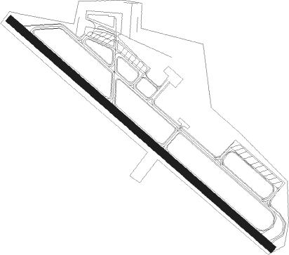
Runway info
| Runway 14 / 32 | ||
| length | 1809m (5935ft) | |
| bearing | 128° / 308° | |
| width | 40m (131ft) | |
| surface | asphalt | |
Nearby beacons
| code | identifier | dist | bearing | frequency |
|---|---|---|---|---|
| SRA | SINTRA VORTAC | 0.2 | 170° | 112.10 |
| STR | SINTRA NDB | 4 | 308° | 371 |
| CAS | CASCAIS VOR/DME | 5.2 | 194° | 114.30 |
| LIS | LISBON VOR/DME | 8.9 | 73° | 114.80 |
| MOJ | MONTIJO TACAN | 16.2 | 112° | 110 |
| LAR | ARRUDA (LISBON) NDB | 17 | 62° | 382 |
| ESP | ESPICHEL VOR/DME | 25.6 | 159° | 112.50 |
| ARR | DME-ILS | 27.1 | 132° | 108.30 |
| MTR | MONTE REAL TACAN | 63.5 | 24° | 109.60 |
| FTM | FATIMA VOR/DME | 63.6 | 46° | 113.50 |
Departure and arrival routes
| Transition altitude | 4000ft |
| SID end points | distance | outbound heading | |
|---|---|---|---|
| RW14 | |||
| PEKO1S | 32mi | 355° | |
| RW32 | |||
| PEKO1N | 32mi | 355° | |
Disclaimer
The information on this website is not for real aviation. Use this data with the X-Plane flight simulator only! Data taken with kind consent from X-Plane 12 source code and data files. Content is subject to change without notice.