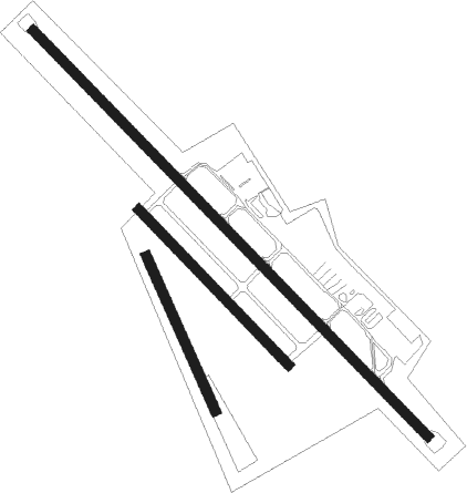
Bern - Bern-belp
Airport details
| Country | Switzerland |
| State | Bern |
| Region | LS |
| Airspace | Switzerland Ctr |
| Municipality | Belp |
| Elevation | 1668ft (508m) |
| Timezone | GMT +1 |
| Coordinates | 46.91086, 7.50366 |
| Magnetic var | |
| Type | land |
| Available since | X-Plane v10.40 |
| ICAO code | LSZB |
| IATA code | BRN |
| FAA code | n/a |
Communication
| Bern-Belp ATIS | 125.130 |
| Bern-Belp CLD | 121.910 |
| Bern-Belp Tower | 119.700 |
| Bern-Belp Tower | 121.025 |
| Bern-Belp Approach | 127.325 |
| Bern-Belp Departure | 127.325 |
Approach frequencies
| ILS-cat-I | RW14 | 110.1 | 18.00mi |
| 4° GS | RW14 | 110.1 | 18.00mi |
Nearby Points of Interest:
Lohn Castle
-reformed church Kleinhöchstetten
-Villa Mettlen
-Blumenhof
-Schloss Hofgut (Gümligen)
-Campagne Rubigen
-Reformierte Kirche Zimmerwald
-Münsingen Psychiatric Center
-Swiss National Library
-Swiss Literary Archives
-Bern city archives
-Swiss Federal Archives
-Erlacherhof
-Béatrice-von-Wattenwyl-Haus
-Worblental
-Stiftsgebäude
-Herrengasse 4
-Villa Morillon
-Herrengasse 23
-Schlössli Sinneringen
-Hôtel de Musique Berne
-Bern
-Bundeskunstsammlung (BKS)
-Library Am Guisanplatz
-Waldau (former infirmary and smallpox house)
Runway info
Nearby beacons
| code | identifier | dist | bearing | frequency |
|---|---|---|---|---|
| FRI | FRIBOURG VOR/DME | 14 | 245° | 110.85 |
| GRE | GRENCHEN VOR/DME | 16.7 | 343° | 115.45 |
| WIL | WILLISAU VOR/DME | 22.9 | 56° | 116.90 |
| LPS | LES EPLATURES NDB | 30.8 | 284° | 403 |
| HOC | DME | 34 | 16° | 113.20 |
| BS | BASLE-MULHOUSE NDB | 40.1 | 3° | 376 |
| SIO | SION VOR/DME | 42.6 | 197° | 112.15 |
| MB | MONTBELIARD NDB | 42.7 | 316° | 330 |
| BLM | BASLE-MULHOUSE VOR/DME | 43.3 | 360° | 117.45 |
| BN | BASLE-MULHOUSE NDB | 45.1 | 358° | 353 |
| HR | HERICOURT NDB | 50.1 | 310° | 289 |
| TRA | DME | 60.2 | 50° | 114.30 |
Departure and arrival routes
| Transition altitude | 6000ft |
| SID end points | distance | outbound heading | |
|---|---|---|---|
| RW14 | |||
| MONI3S | 24mi | 115° | |
| RW32 | |||
| MEBO3B | 11mi | 31° | |
| MONI3B | 24mi | 115° | |
| STAR starting points | distance | inbound heading | |
|---|---|---|---|
| ALL | |||
| TELN3M | 12.6 | 59° | |
| FRI3M | 14.0 | 65° | |
| ROTO3M | 19.0 | 218° | |
| WIL3M | 22.9 | 236° | |
| MONI3M | 24.1 | 295° | |
Instrument approach procedures
| runway | airway (heading) | route (dist, bearing) |
|---|---|---|
| RW14 | BIRKI (129°) | BIRKI 4000ft |
| RW14 | ZB609 (129°) | ZB609 BIRKI (turn) 4000ft |
| RNAV | BIRKI 4000ft ZB619 (2mi, 129°) 4000ft LSZB (6mi, 129°) 1718ft ZB620 (turn) ZB621 (5mi, 57°) 5500ft RAMOK (5mi, 55°) ZB608 (8mi, 279°) BIRKI (5mi, 252°) BIRKI (turn) |
Holding patterns
| STAR name | hold at | type | turn | heading* | altitude | leg | speed limit |
|---|---|---|---|---|---|---|---|
| FRI3M | BIRKI | VHF | right | 318 (138)° | 4000ft - 11000ft | 1.0min timed | 170 |
| MONI3M | BIRKI | VHF | right | 318 (138)° | 4000ft - 11000ft | 1.0min timed | 170 |
| ROTO3M | BIRKI | VHF | right | 318 (138)° | 4000ft - 11000ft | 1.0min timed | 170 |
| TELN3M | BIRKI | VHF | right | 318 (138)° | 4000ft - 11000ft | 1.0min timed | 170 |
| WIL3M | BIRKI | VHF | right | 318 (138)° | 4000ft - 11000ft | 1.0min timed | 170 |
| *) magnetic outbound (inbound) holding course | |||||||
Disclaimer
The information on this website is not for real aviation. Use this data with the X-Plane flight simulator only! Data taken with kind consent from X-Plane 12 source code and data files. Content is subject to change without notice.

