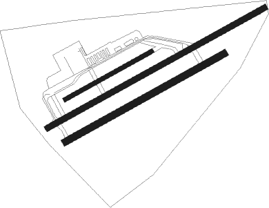
Grenchen
Airport details
| Country | Switzerland |
| State | Solothurn |
| Region | LS |
| Airspace | Switzerland Ctr |
| Municipality | Grenchen |
| Elevation | 1411ft (430m) |
| Timezone | GMT +1 |
| Coordinates | 47.18219, 7.41323 |
| Magnetic var | |
| Type | land |
| Available since | X-Plane v10.40 |
| ICAO code | LSZG |
| IATA code | ZHI |
| FAA code | n/a |
Communication
| Grenchen ATIS | 121.100 |
| Grenchen Ground | 121.800 |
| Grenchen Tower | 120.100 |
| Grenchen Departure | 119.700 |
Nearby Points of Interest:
Grenchen
-city archive
-Altreu (medieval town abandoned)
-Staatsarchiv des Kantons Solothurn
-city archive Solothurn
-Zentralbibliothek Solothurn
-Kapuzinerkloster Solothurn
-solothurn youth hostel
-Solothurn
-Palais Besenval
-Reithalle
-Saint Verena hermitage and sanctuary
-Steinbrugg Castle
-reformed church
-Moutier
-Taubenloch
-Ankli foundation for the Martinet de Corcelles
-reformed city church
-Biel/Bienne
-local museum in the tower house
-Choindez
-Col de Pierre Pertuis
-Eglise Du Christ-Roi
-former St. John commandry
Runway info
Nearby beacons
| code | identifier | dist | bearing | frequency |
|---|---|---|---|---|
| GRE | GRENCHEN VOR/DME | 0.2 | 79° | 115.45 |
| HOC | DME | 19.9 | 42° | 113.20 |
| WIL | WILLISAU VOR/DME | 20.1 | 90° | 116.90 |
| BS | BASLE-MULHOUSE NDB | 24.3 | 17° | 376 |
| FRI | FRIBOURG VOR/DME | 25.5 | 205° | 110.85 |
| LPS | LES EPLATURES NDB | 26 | 261° | 403 |
| BLM | BASLE-MULHOUSE VOR/DME | 27.2 | 11° | 117.45 |
| MB | MONTBELIARD NDB | 27.7 | 303° | 330 |
| BN | BASLE-MULHOUSE NDB | 28.9 | 8° | 353 |
| HR | HERICOURT NDB | 35.8 | 299° | 289 |
| LAP | PRAZ DME | 51 | 243° | 110.65 |
| HO | COLMAR-HOUSSEN NDB | 57.1 | 357° | 380 |
| SIO | SION VOR/DME | 58.2 | 187° | 112.15 |
| SPR | ST PREX VOR/DME | 58.3 | 234° | 113.90 |
Departure and arrival routes
| Transition altitude | 6000ft |
| SID end points | distance | outbound heading | |
|---|---|---|---|
| ALL | |||
| WIL1V | 20mi | 90° | |
| BIRK6V | 10mi | 192° | |
| FRI9V | 26mi | 205° | |
| RW06 | |||
| ARVA1K | 13mi | 81° | |
| WIL1K | 20mi | 90° | |
| BIRK1K | 10mi | 192° | |
| FRI1K | 26mi | 205° | |
| RW24 | |||
| ARVA1W | 13mi | 81° | |
| WIL1W | 20mi | 90° | |
| BIRK1W | 10mi | 192° | |
| FRI1W | 26mi | 205° | |
Instrument approach procedures
| runway | airway (heading) | route (dist, bearing) |
|---|---|---|
| RW24 | WIL (270°) | WIL 6000ft NEMAG (5mi, 315°) 6000ft |
| RNAV | NEMAG 6000ft ZG506 (1mi, 261°) 6000ft ARVAN (3mi, 261°) 6000ft ZG503 (11mi, 261°) 1986ft GRE (2mi, 261°) ZG504 (2mi, 250°) ZG505 (2mi, 138°) 4400ft WIL (21mi, 85°) 6000ft |
Disclaimer
The information on this website is not for real aviation. Use this data with the X-Plane flight simulator only! Data taken with kind consent from X-Plane 12 source code and data files. Content is subject to change without notice.

