Linden - James Tucker
Airport details
| Country | United States of America |
| State | Tennessee |
| Region | K7 |
| Airspace | Memphis Ctr |
| Municipality | Perry County |
| Elevation | 740ft (226m) |
| Timezone | GMT -6 |
| Coordinates | 35.59484, -87.87663 |
| Magnetic var | |
| Type | land |
| Available since | X-Plane v10.40 |
| ICAO code | M15 |
| IATA code | n/a |
| FAA code | n/a |
Communication
| James Tucker CTAF | 122.900 |
Nearby Points of Interest:
Perry County Courthouse
-Hufstedler Gravehouse
-John P. Rains Hotel
-Lewis County Courthouse
-Thompsie Edwards House
-William Thompson House
-Cherry Mansion
-Greyhound Half-Way House
-Webster Farm
-Hamlett-Smith House
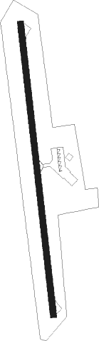
Runway info
| Runway 18 / 36 | ||
| length | 1098m (3602ft) | |
| bearing | 178° / 358° | |
| width | 23m (75ft) | |
| surface | asphalt | |
Nearby beacons
| code | identifier | dist | bearing | frequency |
|---|---|---|---|---|
| GHM | (CENTERVILLE) DME | 25.2 | 61° | 111.60 |
| UU | SEYER (CORINTH) NDB | 50.2 | 232° | 334 |
| MSL | MUSCLE SHOALS VORTAC | 56.5 | 157° | 116.50 |
| CK | SNUFF(FT CAMPBELL (CLARKSVILLE NDB | 60.8 | 28° | 335 |
| DCU | DME | 73.1 | 135° | 112.80 |
Disclaimer
The information on this website is not for real aviation. Use this data with the X-Plane flight simulator only! Data taken with kind consent from X-Plane 12 source code and data files. Content is subject to change without notice.