Airports for X-Plane offers a convenient way to explore airports and their related communication information for the X-Plane flight simulator. It only uses data from the X-Plane flight simulator itself, and is therefore more reliable than the data that comes from real aviation websites. You can search for airports by using the ICAO code, or browse for airports per country and state. The information displayed is categorized by airport details, runway information, airport communication, approach frequencies (ILS and Glidepath details), details of nearby beacons, SIDs, STARs and approach procedures.

traffic airdrome stolport flown station runway airport check-in commuter aircraft carrier city customs landing area airplane near passenger airport airport authority field international passengers

Bald Knob - Bald Knob Muni

Airport details

CountryUnited States of America
StateArkansas
Region
AirspaceMemphis Ctr
MunicipalityBald Knob
Elevation208ft (63m)
TimezoneGMT -6
Coordinates35.30056, -91.56133
Magnetic var
Typeland
Available sinceX-Plane v10.32
ICAO codeM74
IATA coden/a
FAA codeM74

Communication

Bald Knob Muni CTAF122.900
Nearby Points of Interest:
Missouri Pacific Depot
-
Moody House
-
Luke Bone Grocery-Boarding House
-
Jameson-Richards Gas Station
-
Jameson-Richards Cafe
-
Elm Street House
-
Brown House
-
Campbell-Chrisp House
-
St. Richard's Catholic Church
-
Collison House
-
Jack Wood House
-
Capt. Larned House
-
Judsonia Community Building Historic District
-
James W. Edie House
-
Jim Wright Farmstead Historic District
-
C.D. Kelly House
-
Judsonia Bridge
-
Russell Jail
-
Henry W. Klotz Sr. Service Station
-
Henry Klotz Sr. House
-
Louis Gray Homestead, Barn
-
Big Four School
-
Rock Building
-
Fredonia Cemetery
-
Otha Walker Homestead

Runway info

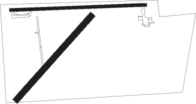
Runway 9 / 27  
 length679m (2228ft)
 bearing92° / 272°
 width15m (50ft)
 surfaceasphalt
 displ threshold75m (246ft) / 47m (154ft)
Runway 04 / 22  
 length565m (1854ft)
 bearing52° / 232°
 width30m (100ft)
 surfacegrass

Airport layout


Parking locations

Nearby beacons

codeidentifierdistbearingfrequency
DSCERCY (SEARCY) NDB14.5228°375
BVALMND (BATESVILLE) NDB26.8330°335
LRFJACKSONVILLE TACAN37.2237°109.20
TTSTUTT (STUTTGART) NDB47.7181°338
LITLITTLE ROCK VORTAC48.2225°113.90
LILASKY (LITTLE ROCK) NDB52.7230°353
ARGWALNUT RIDGE VORTAC56.937°114.50
JBRJONESBORO VOR/DME58.759°108.60
UJMMARVELL (HELENA) VOR/DME61.6129°109.60
TNZLAWRENCE COUNTY (WALNUT RIDGE) NDB62.635°227
FLPDME74.2318°116.05

Disclaimer

The information on this website is not for real aviation. Use this data with the X-Plane flight simulator only! Data taken with kind consent from X-Plane 12 source code and data files. Content is subject to change without notice.