Forest Hill
Airport details
| Country | United States of America |
| State | Maryland |
| Region | K6 |
| Airspace | New York Ctr |
| Municipality | Harford County |
| Elevation | 497ft (151m) |
| Timezone | GMT -5 |
| Coordinates | 39.57940, -76.37402 |
| Magnetic var | |
| Type | land |
| Available since | X-Plane v10.40 |
| ICAO code | MD31 |
| IATA code | n/a |
| FAA code | MD31 |
Communication
Nearby Points of Interest:
The Vineyard
-Bel Air Courthouse Historic District
-Graham-Crocker House
-Harford National Bank
-Rockdale
-Joshua's Meadows
-Tudor Hall
-Dibb House
-D. H. Springhouse
-Gladden Farm
-Bon Air
-Medical Hall Historic District
-Woodview
-Priest Neal's Mass House and Mill Site
-Col. John Streett House
-Webster's Forest
-Broom's Bloom
-Mount Adams
-Olney
-Hidden Valley Farm
-Lower Deer Creek Valley Historic District
-Best Endeavor
-Fair Meadows
-Jerusalem Mill Village
-Jericho Farm
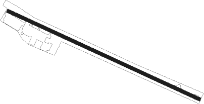
Runway info
| Runway 13 / 31 | ||
| length | 989m (3245ft) | |
| bearing | 113° / 293° | |
| width | 15m (50ft) | |
| surface | asphalt | |
| displ threshold | 278m (912ft) / 0m (0ft) | |
Nearby beacons
| code | identifier | dist | bearing | frequency |
|---|---|---|---|---|
| MTN | MARTIN (BALTIMORE) TACAN | 15 | 189° | 134.10 |
| FND | ELLICOTT (BALTIMORE) NDB | 25.6 | 234° | 371 |
| BAL | BALTIMORE VORTAC | 27.9 | 215° | 115.10 |
| EMI | WESTMINSTER VORTAC | 28.4 | 262° | 117.90 |
| LRP | LANCASTER VOR/DME | 32.6 | 9° | 117.30 |
| BUH | ANNE ARUNDEL (FT MEADE) NDB | 34.7 | 218° | 260 |
| IL | HADIN (WILMINGTON) NDB | 35.1 | 90° | 248 |
| DQO | DUPONT (WILMINGTON) VORTAC | 35.9 | 83° | 114 |
| MXE | MODENA VORTAC | 38.3 | 64° | 113.20 |
| ENO | SMYRNA (KENTON) VORTAC | 44.9 | 112° | 111.40 |
| CX | LATLE (HARRISBURG) NDB | 46.2 | 313° | 219 |
| MD | ENOLA (HARRISBURG) NDB | 46.8 | 322° | 204 |
| DOV | DOVER TACAN | 49.9 | 116° | 110 |
| ADW | ANDREWS (CAMP SPRINGS) VORTAC | 51.7 | 213° | 113.10 |
| BZJ | BELLGROVE (INDIANTOWN GAP) NDB | 52 | 348° | 328 |
| GTN | GEORGETOWN (WASH., D.C.) NDB | 52.3 | 229° | 323 |
| DCA | WASHINGTON, D.C. VOR/DME | 53 | 223° | 111 |
| PTW | POTTSTOWN VORTAC | 53.8 | 52° | 116.50 |
| HAR | HARRISBURG VORTAC | 53.9 | 316° | 112.50 |
| OTT | NOTTINGHAM VORTAC | 55.2 | 203° | 113.70 |
| DCA | OXONN (WASHINGTON) NDB | 57.5 | 219° | 332 |
| RAV | RAVINE VORTAC | 59.4 | 347° | 114.60 |
| DAA | DAVEE (FT BELVOIR) NDB | 64.9 | 219° | 223 |
Instrument approach procedures
| runway | airway (heading) | route (dist, bearing) |
|---|---|---|
| RW31 | CURVY (263°) | CURVY LOVIC (4mi, 233°) 3000ft |
| RW31 | ODESA (279°) | ODESA LOVIC (13mi, 288°) 3000ft |
| RNAV | LOVIC 3000ft MRRTN (9mi, 262°) 2100ft YERUY (4mi, 285°) 692ft (4776mi, 117°) 897ft CURVY (4761mi, 298°) 3000ft CURVY (turn) |
Disclaimer
The information on this website is not for real aviation. Use this data with the X-Plane flight simulator only! Data taken with kind consent from X-Plane 12 source code and data files. Content is subject to change without notice.