Rio Dulce
Airport details
| Country | Guatemala |
| State | Izabal |
| Region | MG |
| Airspace | Central American Ctr |
| Municipality | Livingston |
| Elevation | 63ft (19m) |
| Timezone | GMT -6 |
| Coordinates | 15.66889, -88.96278 |
| Magnetic var | |
| Type | land |
| Available since | X-Plane v10.40 |
| ICAO code | MGRD |
| IATA code | LCF |
| FAA code | n/a |
Communication
| Rio Dulce COM 2 | 123.800 |
| Rio Dulce COM 1 | 123.000 |
| Rio Dulce FIR | 126.900 |
Nearby Points of Interest:
Punta de Manabique
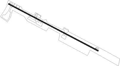
Runway info
| Runway 12 / 30 | ||
| length | 1000m (3281ft) | |
| bearing | 121° / 301° | |
| width | 10m (34ft) | |
| surface | asphalt | |
Nearby beacons
| code | identifier | dist | bearing | frequency |
|---|---|---|---|---|
| BAR | PUERTO BARRIOS NDB | 21.6 | 80° | 347 |
| IOS | PUERTO BARRIOS VOR/DME | 22 | 80° | 115.10 |
Disclaimer
The information on this website is not for real aviation. Use this data with the X-Plane flight simulator only! Data taken with kind consent from X-Plane 12 source code and data files. Content is subject to change without notice.