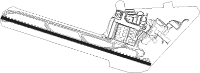
Kingston - Norman Manley Intl
Airport details
| Country | Jamaica |
| State | Kingston |
| Region | MK |
| Airspace | Kingston Ctr |
| Municipality | Saint Andrew |
| Elevation | 7ft (2m) |
| Timezone | GMT -5 |
| Coordinates | 17.93556, -76.78750 |
| Magnetic var | |
| Type | land |
| Available since | X-Plane v10.40 |
| ICAO code | MKJP |
| IATA code | KIN |
| FAA code | n/a |
Communication
| Norman Manley Intl ATIS | 127.700 |
| Norman Manley Intl Clearance Delivery | 128.100 |
| Norman Manley Intl Ground Control | 121.700 |
| Norman Manley Intl MANLEY Tower | 118.650 |
| Norman Manley Intl MANLEY Approach | 120.600 |
Approach frequencies
| ILS-cat-I | RW12 | 109.1 | 18.00mi |
| 3° GS | RW12 | 109.1 | 18.00mi |
Nearby Points of Interest:
Hibbert House
-Blue and John Crow Mountains
Nearby beacons
| code | identifier | dist | bearing | frequency |
|---|---|---|---|---|
| MLY | MANLEY (KINGSTON) VOR/DME | 0.6 | 118° | 115.50 |
Departure and arrival routes
| Transition altitude | 17000ft |
| Transition level | 18000ft |
| SID end points | distance | outbound heading | |
|---|---|---|---|
| RW12 | |||
| LEXUV5 | 71mi | 25° | |
| ENEKA7 | 152mi | 92° | |
| TIBEL3 | 40mi | 113° | |
| AMEKO2 | 16mi | 117° | |
| URMAN3 | 40mi | 128° | |
| OMPAL3 | 40mi | 144° | |
| ALPEN3 | 40mi | 164° | |
| DATOM3 | 40mi | 197° | |
| MLY7 | 42mi | 309° | |
| RADOK7 | 30mi | 348° | |
| RW30 | |||
| ENEKA7 | 152mi | 92° | |
| TIBEL3 | 40mi | 113° | |
| URMAN3 | 40mi | 128° | |
| OMPAL3 | 40mi | 144° | |
| ALPEN3 | 40mi | 164° | |
| DATOM3 | 40mi | 197° | |
| KEYNO2 | 16mi | 294° | |
| GUDIL5 | 42mi | 309° | |
| RADOK7 | 30mi | 348° | |
| STAR starting points | distance | inbound heading | |
|---|---|---|---|
| RW12 | |||
| ELSER5 | 14.3 | 111° | |
| KEYNO3 | 16.3 | 114° | |
Instrument approach procedures
| runway | airway (heading) | route (dist, bearing) |
|---|---|---|
| RW12 | BORAV (86°) | BORAV 9000ft DAMUX (11mi, 75°) 4800ft OMLOD (6mi, 23°) 4000ft |
| RW12 | TAMAP (136°) | TAMAP 6600ft OMLOD (8mi, 203°) 4000ft |
| RNAV | OMLOD 4000ft ANVIN (6mi, 111°) 2800ft URTOP (4mi, 111°) 2000ft ALNOX (5mi, 111°) 500ft MKJP (2mi, 111°) 58ft (4651mi, 103°) 500ft PYNER (4645mi, 283°) 4000ft PYNER (turn) 4000ft | |
| RW30 | BADOW (293°) | BADOW 9000ft WASOT (16mi, 294°) 3000ft |
| RW30 | DUSIL (343°) | DUSIL 9000ft BOTUL (13mi, 23°) 4000ft WASOT (5mi, 23°) 3000ft |
| RNAV | WASOT 3000ft AVREL (7mi, 291°) 2000ft MKJP (7mi, 291°) 68ft MARAG (17mi, 163°) 3000ft MARAG (turn) 3000ft |
Disclaimer
The information on this website is not for real aviation. Use this data with the X-Plane flight simulator only! Data taken with kind consent from X-Plane 12 source code and data files. Content is subject to change without notice.
