Hermosillo - Gral Ignacio P Garcia Intl
Airport details
| Country | Mexico |
| State | Sonora |
| Region | MM |
| Airspace | Mazatlan Ctr |
| Municipality | Hermosillo |
| Elevation | 625ft (190m) |
| Timezone | GMT -7 |
| Coordinates | 29.09287, -111.04242 |
| Magnetic var | |
| Type | land |
| Available since | X-Plane v10.40 |
| ICAO code | MMHO |
| IATA code | HMO |
| FAA code | n/a |
Communication
| Gral Ignacio P Garcia Intl ATIS | 127.700 |
| Gral Ignacio P Garcia Intl HERMOSILLO Tower | 118.700 |
| Gral Ignacio P Garcia Intl HERMOSILLO Approach | 121.400 |
Runway info
| Runway 05 / 23 | ||
| length | 2303m (7556ft) | |
| bearing | 62° / 242° | |
| width | 45m (148ft) | |
| surface | asphalt | |
| blast zone | 56m (184ft) / 58m (190ft) | |
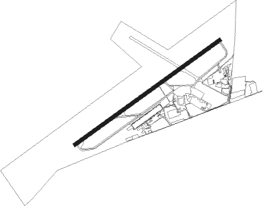
Airport layout
Taxiway locations
Parking locations
Nearby beacons
| code | identifier | dist | bearing | frequency |
|---|---|---|---|---|
| HMO | HERMOSILLO VOR/DME | 0.5 | 285° | 112.80 |
Departure and arrival routes
| Transition altitude | 18500ft |
| Transition level | 19500ft |
| SID end points | distance | outbound heading | |
|---|---|---|---|
| RW05 | |||
| SUVLI3 | 30mi | 1° | |
| BOPA1B | 61mi | 2° | |
| ONBIR3 | 25mi | 4° | |
| DUVUV2 | 30mi | 21° | |
| VENUS4 | 30mi | 59° | |
| IGTA1B | 59mi | 93° | |
| OMIKA2 | 24mi | 93° | |
| VIGL1A | 30mi | 131° | |
| MIUR4A | 30mi | 145° | |
| SEBE2A | 80mi | 145° | |
| GYM2B | 68mi | 174° | |
| NOTO2A | 21mi | 175° | |
| KEKM1B | 50mi | 251° | |
| OTUB4A | 31mi | 302° | |
| OMTI2A | 25mi | 315° | |
| LIDU1A | 61mi | 316° | |
| RW23 | |||
| SUVL4B | 30mi | 1° | |
| BOPA1D | 61mi | 2° | |
| ONBI4B | 25mi | 4° | |
| IGTA1D | 59mi | 93° | |
| VIGL1B | 30mi | 131° | |
| SEBE1B | 80mi | 145° | |
| MIUR4B | 30mi | 145° | |
| GYM1C | 68mi | 174° | |
| NOTO2B | 21mi | 175° | |
| KEKM1D | 50mi | 251° | |
| OTNOG2 | 25mi | 252° | |
| OTUB4B | 31mi | 302° | |
| OMTI3B | 25mi | 315° | |
| LIDU1B | 61mi | 316° | |
| STAR starting points | distance | inbound heading | |
|---|---|---|---|
| RW05 | |||
| KEKM1A | 50.3 | 71° | |
| AVTE1A | 60.1 | 122° | |
| BOPA1A | 61.3 | 182° | |
| IGTA1A | 59.3 | 273° | |
| RW23 | |||
| KEKM1C | 50.3 | 71° | |
| AVTE1B | 60.1 | 122° | |
| BOPA1C | 61.3 | 182° | |
| IGTA1C | 59.3 | 273° | |
| NABL1B | 79.5 | 311° | |
Instrument approach procedures
| runway | airway (heading) | route (dist, bearing) |
|---|---|---|
| RW05 | ILUDA (85°) | ILUDA 4000ft HO800 (5mi, 145°) 3000ft |
| RW05 | MEBSO (63°) | MEBSO 4000ft HO800 (5mi, 62°) 3000ft |
| RW05 | OBRES (39°) | OBRES 4000ft HO800 (5mi, 325°) 3000ft |
| RNAV | HO800 3000ft HO801 (5mi, 62°) 2200ft MMHO (6mi, 65°) 654ft HO802 (2mi, 55°) FULVO (21mi, 178°) FULVO (turn) 4000ft | |
| RW23 | AMEVI (241°) | AMEVI 4000ft HO900 (5mi, 242°) 3000ft |
| RW23 | DUPUS (215°) | DUPUS 4000ft HO900 (5mi, 145°) 3000ft |
| RW23 | GORIG (264°) | GORIG 4000ft HO900 (5mi, 325°) 3000ft |
| RNAV | HO900 3000ft HO901 (4mi, 242°) 2800ft HO902 (2mi, 242°) 2000ft MMHO (4mi, 238°) 677ft HO903 (3mi, 247°) DUPUS (14mi, 42°) 4000ft DUPUS (turn) 4000ft |
Disclaimer
The information on this website is not for real aviation. Use this data with the X-Plane flight simulator only! Data taken with kind consent from X-Plane 12 source code and data files. Content is subject to change without notice.