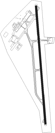
Saltillo - Plan De Guadalupe Intl
Airport details
| Country | Mexico |
| State | Coahuila |
| Region | MM |
| Airspace | Monterrey Ctr |
| Municipality | Ramos Arizpe |
| Elevation | 4776ft (1456m) |
| Timezone | GMT -6 |
| Coordinates | 25.54979, -100.92835 |
| Magnetic var | |
| Type | land |
| Available since | X-Plane v10.40 |
| ICAO code | MMIO |
| IATA code | SLW |
| FAA code | n/a |
Communication
| Plan de Guadalupe Intl Saltillo Tower | 118.400 |
| Plan de Guadalupe Intl Saltillo Tower (Terminal Enroute Control) | 127.400 |
Approach frequencies
| ILS-cat-I | RW17 | 110.1 | 18.00mi |
| 3° GS | RW17 | 110.1 | 18.00mi |
Nearby beacons
| code | identifier | dist | bearing | frequency |
|---|---|---|---|---|
| SLW | SALTILLO VOR/DME | 0.2 | 202° | 116.10 |
| ADN | ROBERTO (MONTERRY) VOR/DME | 41.8 | 65° | 115.40 |
| MTY | MONTERREY VOR/DME | 46.6 | 75° | 114.70 |
Departure and arrival routes
| Transition altitude | 18500ft |
| Transition level | 19500ft |
| SID end points | distance | outbound heading | |
|---|---|---|---|
| RW17 | |||
| HERT1A | 25mi | 7° | |
| ELERA1 | 50mi | 133° | |
| SIGDO2 | 35mi | 180° | |
| OMEVO2 | 35mi | 202° | |
| VOLI1A | 50mi | 249° | |
| RABA1A | 45mi | 303° | |
| RW35 | |||
| HERT1B | 25mi | 7° | |
| NOVU2A | 22mi | 35° | |
| LIRGA1 | 15mi | 133° | |
| VOLI1B | 50mi | 249° | |
| RABA1B | 45mi | 303° | |
| PIKBU2 | 23mi | 339° | |
| STAR starting points | distance | inbound heading | |
|---|---|---|---|
| RW17 | |||
| BERO1A | 44.0 | 0° | |
| FLAN1A | 50.4 | 22° | |
| RAIL1A | 50.3 | 34° | |
| OMIX1A | 30.0 | 90° | |
| NOVU1B | 21.9 | 215° | |
| RW35 | |||
| BERO1B | 44.0 | 0° | |
| FLAN1B | 50.4 | 22° | |
| RAIL1B | 50.3 | 34° | |
| OMIX1B | 30.0 | 90° | |
| NOVU2C | 21.9 | 215° | |
Instrument approach procedures
| runway | airway (heading) | route (dist, bearing) |
|---|---|---|
| RW17 | ILOKA (142°) | ILOKA 10000ft IO506 (8mi, 90°) 8300ft |
| RW17 | KEMTA (199°) | KEMTA 9500ft IO506 (5mi, 243°) 8300ft |
| RNAV | IO506 8300ft IO900 (5mi, 180°) 6800ft MMIO (7mi, 180°) 4698ft IO901 (5mi, 180°) OMIXA (30mi, 279°) 10000ft OMIXA (turn) 10000ft | |
| RW35 | ALTUM (49°) | ALTUM 9000ft IO503 (3mi, 90°) 8000ft IO502 (3mi, 90°) 7100ft |
| RW35 | VOLIK (34°) | VOLIK 12000ft IO600 (9mi, 30°) 9300ft IO504 (5mi, 58°) 8000ft IO502 (3mi, 58°) 7100ft |
| RNAV | IO502 7100ft IO501 (2mi, 32°) 6500ft IO500 (2mi, 32°) 5900ft MMIO (4mi, 360°) 4828ft IO700 (3mi, 360°) OMIXA (30mi, 265°) 10000ft OMIXA (turn) 10000ft |
Disclaimer
The information on this website is not for real aviation. Use this data with the X-Plane flight simulator only! Data taken with kind consent from X-Plane 12 source code and data files. Content is subject to change without notice.