Monterrey - General Mariano Escobedo Intl
Airport details
| Country | Mexico |
| State | Nuevo León |
| Region | MM |
| Airspace | Monterrey Ctr |
| Municipality | Apodaca |
| Elevation | 1273ft (388m) |
| Timezone | GMT -6 |
| Coordinates | 25.77322, -100.10862 |
| Magnetic var | |
| Type | land |
| Available since | X-Plane v10.40 |
| ICAO code | MMMY |
| IATA code | MTY |
| FAA code | n/a |
Communication
| General Mariano Escobedo Intl ATIS | 127.700 |
| General Mariano Escobedo Intl Ground Control | 121.900 |
| General Mariano Escobedo Intl MONTERREY Tower | 118.100 |
| General Mariano Escobedo Intl MONTERREY Approach | 121.400 |
| General Mariano Escobedo Intl MONTERREY Arrival | 120.400 |
| General Mariano Escobedo Intl MONTERREY Approach | 119.750 |
Approach frequencies
| ILS-cat-I | RW29 | 111.1 | 18.00mi |
| 3° GS | RW29 | 111.1 | 18.00mi |
Runway info
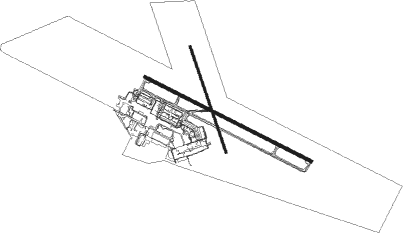
Runway 11 / 29  | ||
| length | 3002m (9849ft) | |
| bearing | 119° / 299° | |
| width | 45m (148ft) | |
| surface | asphalt | |
| blast zone | 61m (200ft) / 62m (203ft) | |
| Runway 16 / 34 | ||
| length | 1808m (5932ft) | |
| bearing | 164° / 344° | |
| width | 30m (98ft) | |
| surface | asphalt | |
| blast zone | 66m (217ft) / 66m (217ft) | |
Nearby beacons
| code | identifier | dist | bearing | frequency |
|---|---|---|---|---|
| MTY | MONTERREY VOR/DME | 0.2 | 95° | 114.70 |
| ADN | ROBERTO (MONTERRY) VOR/DME | 8.9 | 305° | 115.40 |
| SLW | SALTILLO VOR/DME | 46.5 | 255° | 116.10 |
Departure and arrival routes
| Transition altitude | 18500ft |
| Transition level | 19500ft |
| SID end points | distance | outbound heading | |
|---|---|---|---|
| RW11 | |||
| DAJO1A | 50mi | 34° | |
| URTA4A | 20mi | 34° | |
| OVEM4A | 20mi | 51° | |
| DOTO1A | 49mi | 90° | |
| EMAK2A | 20mi | 90° | |
| XOTAT3 | 20mi | 105° | |
| URSU3A | 30mi | 173° | |
| KERG1A | 50mi | 173° | |
| URTO3A | 30mi | 221° | |
| GRAL1A | 59mi | 296° | |
| RW29 | |||
| DAJO1B | 50mi | 34° | |
| URTA3B | 20mi | 34° | |
| OVEM4B | 20mi | 51° | |
| DOTO1B | 49mi | 90° | |
| KERG1B | 50mi | 173° | |
| URTO3B | 30mi | 221° | |
| UBVIV1 | 30mi | 278° | |
| GRAL1B | 59mi | 296° | |
| GABLA3 | 30mi | 296° | |
| URTU3A | 20mi | 352° | |
| STAR starting points | distance | inbound heading | |
|---|---|---|---|
| RW11 | |||
| SLW1B | 46.5 | 75° | |
| NOTA1A | 46.5 | 172° | |
| ITPI1A | 50.1 | 256° | |
| RETO1A | 50.2 | 310° | |
| RW29 | |||
| SLW1C | 46.5 | 75° | |
| NOTA1B | 46.5 | 172° | |
| ITPI1B | 50.1 | 256° | |
| RETO1B | 50.2 | 310° | |
Instrument approach procedures
| runway | airway (heading) | route (dist, bearing) |
|---|---|---|
| RW11 | TASNA (120°) | TASNA 4800ft MY603 (5mi, 119°) 3700ft |
| RNAV | MY603 3700ft MY604 (2mi, 119°) 3300ft MMMY (7mi, 121°) 1326ft MY607 (2mi, 111°) CLOVR (16mi, 119°) 6000ft CLOVR (turn) 6000ft | |
| RW29 | OKOTO (297°) | OKOTO 4400ft MY403 (5mi, 299°) 3400ft |
| RNAV | MY403 3400ft MY408 (2mi, 299°) 3000ft MMMY (6mi, 296°) 1290ft MY405 (2mi, 307°) MY406 (9mi, 82°) MY407 (7mi, 119°) CLOVR (9mi, 157°) 6000ft CLOVR (turn) 6000ft |
Holding patterns
| STAR name | hold at | type | turn | heading* | altitude | leg | speed limit |
|---|---|---|---|---|---|---|---|
| ITPI1A | ULAVA | VHF | right | 66 (246)° | > 16000ft | 1.0min timed | 200 |
| ITPI1B | ULAVA | VHF | right | 66 (246)° | > 16000ft | 1.0min timed | 200 |
| *) magnetic outbound (inbound) holding course | |||||||
Disclaimer
The information on this website is not for real aviation. Use this data with the X-Plane flight simulator only! Data taken with kind consent from X-Plane 12 source code and data files. Content is subject to change without notice.