Tampico - General Francisco Javier Mina
Airport details
| Country | Mexico |
| State | Tamaulipas |
| Region | MM |
| Airspace | Mexico Ctr |
| Municipality | Tampico |
| Elevation | 80ft (24m) |
| Timezone | GMT -6 |
| Coordinates | 22.29212, -97.86932 |
| Magnetic var | |
| Type | land |
| Available since | X-Plane v10.40 |
| ICAO code | MMTM |
| IATA code | TAM |
| FAA code | n/a |
Communication
| General Francisco Javier Mina TAMPICO Information | 122.450 |
| General Francisco Javier Mina TAMPICO Tower | 118.300 |
| General Francisco Javier Mina TAMPICO Approach | 120.300 |
Approach frequencies
| ILS-cat-I | RW13 | 109.3 | 18.00mi |
| 3° GS | RW13 | 109.3 | 18.00mi |
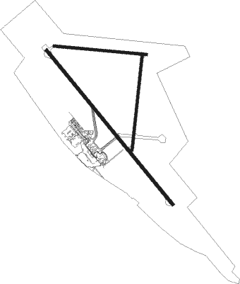
Runway info
Runway 13 / 31  | ||
| length | 2560m (8399ft) | |
| bearing | 143° / 323° | |
| width | 42m (138ft) | |
| surface | asphalt | |
| blast zone | 71m (233ft) / 98m (322ft) | |
| Runway 18 / 36 | ||
| length | 1214m (3983ft) | |
| bearing | 191° / 11° | |
| width | 30m (98ft) | |
| surface | asphalt | |
| blast zone | 7m (23ft) / 116m (381ft) | |
| Runway 09 / 27 | ||
| length | 1192m (3911ft) | |
| bearing | 99° / 279° | |
| width | 30m (98ft) | |
| surface | asphalt | |
| blast zone | 7m (23ft) / 0m (0ft) | |
Nearby beacons
| code | identifier | dist | bearing | frequency |
|---|---|---|---|---|
| TAM | TAMPICO VOR/DME | 0.3 | 112° | 117.50 |
| TMN | TAMUIN VOR/DME | 54.3 | 255° | 113.30 |
Departure and arrival routes
| Transition altitude | 18500ft |
| Transition level | 19500ft |
| SID end points | distance | outbound heading | |
|---|---|---|---|
| RW13 | |||
| ONBU3A | 25mi | 96° | |
| ANIL3A | 25mi | 151° | |
| NOTO2A | 25mi | 166° | |
| LETI2A | 25mi | 200° | |
| RW18 | |||
| ONBU3B | 25mi | 96° | |
| ANIL3B | 25mi | 151° | |
| NOTO2B | 25mi | 166° | |
| LETI2B | 25mi | 200° | |
| IPTU2A | 25mi | 255° | |
| RW31 | |||
| MAPI2A | 25mi | 6° | |
| EMOR2A | 25mi | 14° | |
| AVSE3A | 25mi | 35° | |
| IPTU2B | 25mi | 255° | |
| TAKL2A | 25mi | 290° | |
| JERE2A | 25mi | 323° | |
| XORM2A | 25mi | 339° | |
| URVO2A | 25mi | 355° | |
| RW36 | |||
| MAPI2B | 25mi | 6° | |
| EMOR2B | 25mi | 14° | |
| AVSE3B | 25mi | 35° | |
| TAKL2B | 25mi | 290° | |
| JERE2B | 25mi | 323° | |
| XORM2B | 25mi | 339° | |
| URVO2B | 25mi | 355° | |
Disclaimer
The information on this website is not for real aviation. Use this data with the X-Plane flight simulator only! Data taken with kind consent from X-Plane 12 source code and data files. Content is subject to change without notice.