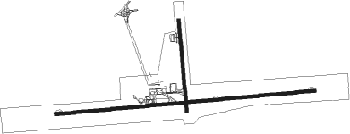
Santiago - Santiago De Cuba
Airport details
| Country | Cuba |
| State | Santiago de Cuba |
| Region | MU |
| Airspace | Havana Ctr |
| Elevation | 249ft (76m) |
| Timezone | GMT -5 |
| Coordinates | 19.97953, -75.83613 |
| Magnetic var | |
| Type | land |
| Available since | X-Plane v10.40 |
| ICAO code | MUCU |
| IATA code | SCU |
| FAA code | n/a |
Communication
| Santiago de Cuba SANTIAGO RDO | 126.900 |
| Santiago de Cuba SANTIAGO Approach | 119.400 |
Approach frequencies
| ILS-cat-I | RW10 | 110.7 | 18.00mi |
| 3° GS | RW10 | 110.7 | 18.00mi |
Nearby Points of Interest:
El Cobre
-Archaeological Landscape of the First Coffee Plantations in the South-East of Cuba
-Niceto Pérez
-Guantánamo
-El Salvador
Nearby beacons
| code | identifier | dist | bearing | frequency |
|---|---|---|---|---|
| UCU | SANTIAGO DE CUBA VOR/DME | 0.7 | 97° | 113.30 |
| NBW | NAVY GUANTANAMO BAY TACAN | 35.1 | 96° | 114.60 |
| UHG | HOLGUIN VOR/DME | 55.7 | 330° | 116.80 |
Departure and arrival routes
| Transition altitude | 6000ft |
| SID end points | distance | outbound heading | |
|---|---|---|---|
| RW10 | |||
| SENSO2 | 110mi | 63° | |
| KENKU3 | 93mi | 155° | |
| KAVO3A | 63mi | 204° | |
| KINI3A, ALOTU4 | 105mi | 293° | |
| HOLGU1 | 115mi | 300° | |
| RW28 | |||
| KAVO3D | 93mi | 155° | |
| KOBI3C | 63mi | 204° | |
| KUBO4C | 56mi | 330° | |
| STAR starting points | distance | inbound heading | |
|---|---|---|---|
| RW10 | |||
| KOBI3A | 36.5 | 48° | |
| MALTA1 | 73.8 | 104° | |
| CAOBA4 | 28.1 | 114° | |
| KAVO3C | 20.3 | 356° | |
| RW28 | |||
| KINI4B | 19.1 | 197° | |
| SENSO3 | 27.7 | 225° | |
| IMOXO3 | 36.3 | 320° | |
| KAVO3B | 20.3 | 356° | |
Instrument approach procedures
| runway | airway (heading) | route (dist, bearing) |
|---|---|---|
| RW01 | ILITO (359°) | ILITO 4000ft |
| RNAV | ILITO 4000ft CU726 (6mi, 359°) 2000ft MUCU (6mi, 359°) 267ft (4607mi, 105°) 1500ft CU723 (4616mi, 285°) 3000ft ILITO (14mi, 136°) 4000ft ILITO (turn) 4000ft | |
| RW10 | CU720 (102°) | CU720 6000ft DARPO (6mi, 155°) 4500ft |
| RW10 | CU721 (68°) | CU721 5000ft DARPO (6mi, 17°) 4500ft |
| RNAV | DARPO 4500ft CU725 (6mi, 87°) 3000ft CU724 (4mi, 87°) 1845ft MUCU (6mi, 82°) 253ft (4607mi, 105°) 2000ft KAVON (4604mi, 285°) 5000ft KAVON (turn) 5000ft | |
| RW28 | CU705 (263°) | CU705 6000ft RORTO (6mi, 190°) 5000ft |
| RW28 | CU706 (297°) | CU706 5000ft RORTO (6mi, 10°) 5000ft |
| RNAV | RORTO 5000ft CU728 (8mi, 279°) 3300ft MAP28 (9mi, 279°) 535ft (4605mi, 105°) 2000ft KAVON (4604mi, 285°) 5000ft KAVON (turn) 5000ft |
Holding patterns
| STAR name | hold at | type | turn | heading* | altitude | leg | speed limit |
|---|---|---|---|---|---|---|---|
| CAOBA4 | CAOBA | VHF | right | 325 (145)° | 6000ft - 14000ft | DME 4.3mi | 230 |
| IMOXO3 | IMOXO | VHF | right | 173 (353)° | 5000ft - 14000ft | DME 4.3mi | 230 |
| KAVO3B | KAVON | VHF | right | 134 (314)° | 5000ft - 14000ft | DME 4.3mi | 230 |
| KAVO3C | KAVON | VHF | right | 134 (314)° | 5000ft - 14000ft | DME 4.3mi | 230 |
| KINI4B | KINIS | VHF | right | 327 (147)° | 6000ft - 14000ft | DME 4.3mi | 230 |
| KOBI3A | KOBIR | VHF | right | 217 (37)° | 5000ft - 14000ft | DME 4.3mi | 230 |
| MALTA1 | MALTA | VHF | right | 294 (114)° | > 7000ft | 1.0min timed | ICAO rules |
| SENSO3 | SENSO | VHF | right | 8 (188)° | 6000ft - 14000ft | DME 4.3mi | 230 |
| *) magnetic outbound (inbound) holding course | |||||||
Disclaimer
The information on this website is not for real aviation. Use this data with the X-Plane flight simulator only! Data taken with kind consent from X-Plane 12 source code and data files. Content is subject to change without notice.

