Cortland - Cortland County
Airport details
| Country | United States of America |
| State | New York |
| Region | K6 |
| Airspace | New York Ctr |
| Municipality | Cortland West |
| Elevation | 1198ft (365m) |
| Timezone | GMT -5 |
| Coordinates | 42.59264, -76.21488 |
| Magnetic var | |
| Type | land |
| Available since | X-Plane v10.40 |
| ICAO code | N03 |
| IATA code | n/a |
| FAA code | n/a |
Communication
| Cortland County AWOS 3 | 132.225 |
| Cortland County CTAF/UNICOM | 122.800 |
| Cortland County SYRACUSE Approach | 126.125 |
| Cortland County BINGHAMTON Approach | 118.600 |
| Cortland County ELMIRA Approach | 124.300 |
| Cortland County SYRACUSE Departure | 126.125 |
Nearby Points of Interest:
Tompkins Street–Main Street Historic District
-United States Post Office
-Randall Farm
-Cortland Fire Headquarters
-First Presbyterian Church Complex
-Cortland Free Library
-Cortland County Courthouse
-William J. Greenman House
-Old Homer Village Historic District
-Water, Wall, and Pine Streets Lenticular Truss Bridges
-Presbyterian Church of McGraw
-Former Groton High School (Groton, New York)
-Southworth House
-Jennings-Marvin House
-Methodist Episcopal Church
-Dryden Historic District
-Southworth Library
-Luther Clarke House
-Lacy-Van Vleet House
-Rockwell House
-Hatheway Homestead
-First Presbyterian Church
-West Dryden Methodist Episcopal Church
-Stage Coach Inn
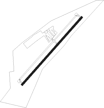
Runway info
| Runway 6 / 24 | ||
| length | 1035m (3396ft) | |
| bearing | 55° / 235° | |
| width | 23m (75ft) | |
| surface | asphalt | |
Nearby beacons
| code | identifier | dist | bearing | frequency |
|---|---|---|---|---|
| IT | VRNAH (ITHACA) NDB | 11.9 | 223° | 266 |
| ITH | DME | 12.3 | 248° | 111.80 |
| GGT | GEORGETOWN TACAN | 20.7 | 63° | 117.80 |
| CFB | BINGHAMTON VOR/DME | 26.3 | 170° | 112.20 |
| ALP | ALPINE (ELMIRA) NDB | 32.3 | 237° | 245 |
| SYR | SYRACUSE VORTAC | 34.1 | 1° | 117 |
| PYA | PENN YAN NDB | 37.3 | 273° | 260 |
| FZ | FALLN (FULTON) NDB | 41.9 | 353° | 220 |
| RKA | ROCKDALE VOR/DME | 43.8 | 97° | 112.60 |
| ULW | ELMIRA VOR/DME | 46.7 | 238° | 109.65 |
| HNK | HANCOCK VOR/DME | 51 | 121° | 116.80 |
Instrument approach procedures
| runway | airway (heading) | route (dist, bearing) |
|---|---|---|
| RW06 | PIPEE (19°) | PIPEE TUTSY (7mi, 308°) 3700ft |
| RW06 | PYPRR (81°) | PYPRR TUTSY (7mi, 128°) 3700ft |
| RW06 | TUTSY (55°) | TUTSY 3700ft |
| RNAV | TUTSY 3700ft NEWON (6mi, 55°) 3000ft N03 (6mi, 55°) 1237ft (4798mi, 119°) 1597ft NORRI (4791mi, 299°) 3700ft NORRI (turn) | |
| RW24 | CKRIS (259°) | CKRIS NORRI (7mi, 308°) 3700ft |
| RW24 | NORRI (235°) | NORRI 3700ft |
| RW24 | WYYIT (203°) | WYYIT NORRI (7mi, 128°) 3700ft |
| RNAV | NORRI 3700ft BAIBE (6mi, 235°) 3500ft GONOF (4mi, 235°) 2220ft N03 (3mi, 235°) 1209ft (4798mi, 119°) 1597ft NORRI (4791mi, 299°) 3700ft NORRI (turn) |
Disclaimer
The information on this website is not for real aviation. Use this data with the X-Plane flight simulator only! Data taken with kind consent from X-Plane 12 source code and data files. Content is subject to change without notice.