Toughkenamon - New Garden
Airport details
| Country | United States of America |
| State | Pennsylvania |
| Region | K6 |
| Airspace | New York Ctr |
| Municipality | New Garden Township |
| Elevation | 436ft (133m) |
| Timezone | GMT -5 |
| Coordinates | 39.83053, -75.76974 |
| Magnetic var | |
| Type | land |
| Available since | X-Plane v10.40 |
| ICAO code | N57 |
| IATA code | n/a |
| FAA code | n/a |
Communication
| New Garden Clearance DEL | 125.600 |
| New Garden CTAF/UNICOM | 123.050 |
| New Garden PHILADELPHIA Approach/Departure | 124.350 |
Nearby Points of Interest:
South Brook Farm
-Joseph Gregg House
-Kennett Square Historic District
-Cedarcroft
-Primitive Hall
-Embreeville Historic District
-Unionville Village Historic District
-Garrett Snuff Mill
-Longwood Gardens
-Gideon Wickersham Farmstead
-Marlborough Village Historic District
-House at Springdell
-Green Valley Historic District
-Cyrus Hoopes House and Barn
-John Ferron House
-Jacob Broom House
-Doe Run Village Historic District
-Thompson Farm
-Mt. Cuba Center
-Moses Ross House
-Harlan Log House
-House at Upper Laurel Iron Works
-Mountain Meadow Farm
-Spruce Grove School
-Joseph Young House
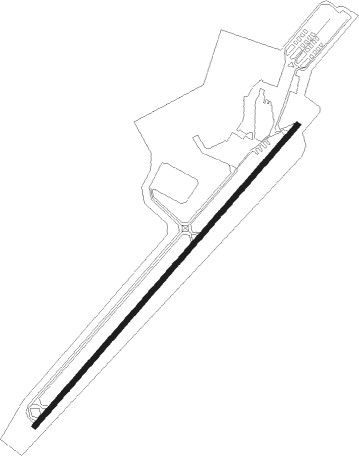
Runway info
| Runway 6 / 24 | ||
| length | 1128m (3701ft) | |
| bearing | 53° / 233° | |
| width | 15m (50ft) | |
| surface | asphalt | |
Nearby beacons
| code | identifier | dist | bearing | frequency |
|---|---|---|---|---|
| MXE | MODENA VORTAC | 6.9 | 48° | 113.20 |
| DQO | DUPONT (WILMINGTON) VORTAC | 11.8 | 133° | 114 |
| IL | HADIN (WILMINGTON) NDB | 16.6 | 148° | 248 |
| OOD | WOODSTOWN VORTAC | 24.5 | 113° | 112.80 |
| PTW | POTTSTOWN VORTAC | 25.4 | 28° | 116.50 |
| ING | AMBLER NDB | 28.4 | 59° | 275 |
| LRP | LANCASTER VOR/DME | 29.6 | 299° | 117.30 |
| ENO | SMYRNA (KENTON) VORTAC | 37.8 | 157° | 111.40 |
| RNB | RAINBOW (MILLVILLE) NDB | 38.4 | 123° | 363 |
| VCN | CEDAR LAKE (MILLVILLE) VOR/DME | 41 | 110° | 115.20 |
| MTN | MARTIN (BALTIMORE) TACAN | 42.2 | 232° | 134.10 |
| DOV | DOVER TACAN | 44.2 | 157° | 110 |
| ETX | EAST TEXAS VOR/DME | 45.2 | 7° | 110.20 |
| ARD | YARDLEY VOR/DME | 47 | 64° | 108.20 |
| BZJ | BELLGROVE (INDIANTOWN GAP) NDB | 51.1 | 308° | 328 |
| FJC | ALLENTOWN VORTAC | 55.7 | 19° | 117.50 |
| BAL | BALTIMORE VORTAC | 57.2 | 234° | 115.10 |
| RAV | RAVINE VORTAC | 57.7 | 311° | 114.60 |
| SIE | SEA ISLE VORTAC | 62.9 | 127° | 114.80 |
| BUH | ANNE ARUNDEL (FT MEADE) NDB | 64.1 | 233° | 260 |
| BWZ | BROADWAY (SCHOOLEY'S MT) VOR/DME | 72.5 | 44° | 114.20 |
Instrument approach procedures
| runway | airway (heading) | route (dist, bearing) |
|---|---|---|
| RW06 | DELFA (53°) | DELFA 2200ft |
| RNAV | DELFA 2200ft ZIXIS (5mi, 53°) 2000ft YOSGU (2mi, 53°) 1240ft N57 (3mi, 53°) 478ft (4752mi, 118°) 800ft ZEYNU (4746mi, 298°) 2200ft ZEYNU (turn) | |
| RW24 | ZEYNU (233°) | ZEYNU 2200ft |
| RNAV | ZEYNU 2200ft ENUKE (5mi, 233°) 2000ft N57 (5mi, 233°) 475ft (4752mi, 118°) 835ft DELFA (4758mi, 298°) 2200ft DELFA (turn) |
Disclaimer
The information on this website is not for real aviation. Use this data with the X-Plane flight simulator only! Data taken with kind consent from X-Plane 12 source code and data files. Content is subject to change without notice.