Manurewa - Ardmore Aerodrome
Airport details
| Country | New Zealand |
| State | Auckland |
| Region | NZ |
| Municipality | Franklin |
| Elevation | 107ft (33m) |
| Timezone | GMT +12 |
| Coordinates | -37.02972, 174.97333 |
| Magnetic var | |
| Type | land |
| Available since | X-Plane v10.30 |
| ICAO code | NZAR |
| IATA code | AMZ |
| FAA code | n/a |
Communication
Nearby Points of Interest:
Chapel of St John the Evangelist, Auckland
-Pah Homestead
-Stoneways
-Albert Barracks Wall
-Auckland Town Hall
-Kenneth Myers Centre
-Auckland Savings Bank Building
-Bluestone Store
-Dilworth Building
-Gluepot Tavern
-Auckland volcanic field
-Firth of Thames
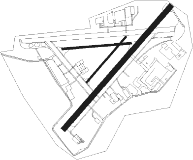
Runway info
Runway 03 / 21  | ||
| length | 1407m (4616ft) | |
| bearing | 52° / 232° | |
| width | 45m (148ft) | |
| surface | asphalt | |
| displ threshold | 104m (341ft) / 109m (358ft) | |
| Runway 07R / 25L | ||
| length | 598m (1962ft) | |
| bearing | 90° / 270° | |
| width | 18m (59ft) | |
| surface | grass | |
| Runway 03L / 21R | ||
| length | 519m (1703ft) | |
| bearing | 52° / 232° | |
| width | 18m (59ft) | |
| surface | grass | |
Nearby beacons
| code | identifier | dist | bearing | frequency |
|---|---|---|---|---|
| AA | AUCKLAND VOR/DME | 7.8 | 279° | 114.80 |
| SY | SURREY NDB | 15.5 | 137° | 350 |
| WI | WAIUKU NDB | 16.1 | 214° | 254 |
| WP | WHENUAPAI (AUCKLAND) VOR/DME | 21.9 | 305° | 116.40 |
| HN | HAMILTON VOR/DME | 52.2 | 156° | 114 |
| CV | CUVIER I. NDB | 52.4 | 54° | 302 |
Departure and arrival routes
| Transition altitude | 13000ft |
| Transition level | 15000ft |
| SID end points | distance | outbound heading | |
|---|---|---|---|
| RW03 | |||
| PATG2Q | 30mi | 342° | |
Instrument approach procedures
| runway | airway (heading) | route (dist, bearing) |
|---|---|---|
| RW03 | GROVE (69°) | GROVE KINGS (4mi, 111°) 2100ft |
| RW03 | KINGS (51°) | KINGS 2100ft KINGS (turn) 2000ft |
| RW03 | WI (34°) | WI KINGS (8mi, 9°) 2100ft |
| RNAV | KINGS 2100ft UBKEL (5mi, 52°) 1400ft AR409 (4mi, 52°) 335ft AR581 (3mi, 52°) AR748 (3mi, 78°) SY (15mi, 158°) 3000ft SY (turn) 3000ft | |
| RW21-Q | EGURU (249°) | EGURU 4000ft |
| RW21-Q | FIRTH (264°) | FIRTH EGURU (7mi, 298°) 2300ft |
| RW21-Q | SATLA (244°) | SATLA EGURU (6mi, 230°) 2300ft |
| RNAV | EGURU 2300ft SARVI (8mi, 254°) 2230ft AR401 (5mi, 246°) 444ft AR871 (5mi, 223°) AR964 (4mi, 192°) SY (13mi, 108°) 3000ft SY (turn) 3000ft | |
| RW21-R | FIRTH (264°) | FIRTH ORERE (6mi, 294°) 2300ft |
| RW21-R | ORERE (253°) | ORERE 3300ft |
| RW21-R | SATLA (244°) | SATLA ORERE (6mi, 221°) 2300ft |
| RNAV | ORERE 2300ft EMTUB (7mi, 258°) 2260ft AR401 (6mi, 250°) 439ft AR572 (5mi, 223°) AR683 (5mi, 192°) SY (13mi, 108°) 3000ft SY (turn) 3000ft |
Disclaimer
The information on this website is not for real aviation. Use this data with the X-Plane flight simulator only! Data taken with kind consent from X-Plane 12 source code and data files. Content is subject to change without notice.