Gisborne
Airport details
| Country | New Zealand |
| State | Gisborne |
| Region | NZ |
| Elevation | 14ft (4m) |
| Timezone | GMT +12 |
| Coordinates | -38.66333, 177.97833 |
| Magnetic var | |
| Type | land |
| Available since | X-Plane v10.40 |
| ICAO code | NZGS |
| IATA code | GIS |
| FAA code | n/a |
Communication
| Gisborne GISBORNE ATIS | 126.400 |
| Gisborne GISBORNE Tower | 127.300 |
| Gisborne GISBORNE ApproachROACH | 118.200 |
| Gisborne CHCH CTL Departure | 119.500 |
Nearby Points of Interest:
Tolaga Bay Wharf
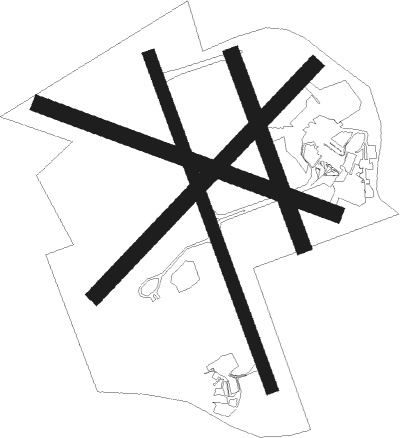
Runway info
Runway 14 / 32  | ||
| length | 1311m (4301ft) | |
| bearing | 160° / 340° | |
| width | 46m (151ft) | |
| surface | asphalt | |
| Runway 03 / 21 | ||
| length | 1175m (3855ft) | |
| bearing | 55° / 235° | |
| width | 60m (197ft) | |
| surface | grass | |
| Runway 09 / 27 | ||
| length | 1169m (3835ft) | |
| bearing | 110° / 290° | |
| width | 60m (197ft) | |
| surface | grass | |
| Runway 14L / 32R | ||
| length | 751m (2464ft) | |
| bearing | 160° / 340° | |
| width | 60m (197ft) | |
| surface | grass | |
Nearby beacons
| code | identifier | dist | bearing | frequency |
|---|---|---|---|---|
| GS | GISBORNE VOR/DME | 0.1 | 345° | 114.20 |
Departure and arrival routes
| Transition altitude | 13000ft |
| Transition level | 15000ft |
| SID end points | distance | outbound heading | |
|---|---|---|---|
| RW14 | |||
| POPAD2 | 15mi | 299° | |
| RW32 | |||
| NODEX2 | 15mi | 305° | |
| STAR starting points | distance | inbound heading | |
|---|---|---|---|
| RW14 | |||
| HAWK3A | 19.9 | 55° | |
| ELME1A | 17.9 | 88° | |
| RW32 | |||
| HAWK2B | 19.9 | 55° | |
| CREK2B | 15.0 | 108° | |
| OTOK3B | 15.1 | 125° | |
Instrument approach procedures
| runway | airway (heading) | route (dist, bearing) |
|---|---|---|
| RW14 | CREEK (108°) | CREEK RUGRU (11mi, 76°) 2700ft |
| RW14 | EWOOD (119°) | EWOOD RUGRU (6mi, 69°) 2700ft |
| RW14 | OTOKO (125°) | OTOKO RUGRU (8mi, 95°) 2700ft |
| RW14 | WARIK (119°) | WARIK RUGRU (9mi, 87°) 2700ft |
| RNAV | RUGRU 2700ft SALEK (5mi, 149°) 1650ft NZGS (5mi, 159°) 62ft KOPUA (9mi, 161°) 2700ft KOPUA (turn) 2700ft | |
| RW32 | COOKS (342°) | COOKS KOPUA (5mi, 344°) 2000ft |
| RW32 | UKLIP (35°) | UKLIP KOPUA (9mi, 79°) 3500ft |
| RNAV | KOPUA 2000ft VESAV (5mi, 340°) 1340ft NZGS (4mi, 341°) 65ft KOPUA (9mi, 161°) 2700ft KOPUA (turn) 2700ft |
Holding patterns
| STAR name | hold at | type | turn | heading* | altitude | leg | speed limit |
|---|---|---|---|---|---|---|---|
| GS2B | GS | NDB | right | 313 (133)° | > 3000ft | 1.0min timed | ICAO rules |
| GS2B | KOPUA | VHF | right | 143 (323)° | > 2700ft | 1.0min timed | 210 |
| GS3A | GS | NDB | right | 313 (133)° | > 3000ft | 1.0min timed | ICAO rules |
| HAWK2B | HAWKE | VHF | left | 207 (27)° | > 4300ft | DME 6.0mi | ICAO rules |
| HAWK3A | HAWKE | VHF | left | 207 (27)° | > 4300ft | DME 6.0mi | ICAO rules |
| KOPU3A | KOPUA | VHF | right | 143 (323)° | > 2700ft | 1.0min timed | 210 |
| *) magnetic outbound (inbound) holding course | |||||||
Disclaimer
The information on this website is not for real aviation. Use this data with the X-Plane flight simulator only! Data taken with kind consent from X-Plane 12 source code and data files. Content is subject to change without notice.