Kaikohe Aerodrome - Kaikohe
Airport details
| Country | New Zealand |
| State | Northland |
| Region | NZ |
| Municipality | Kaikohe-Hokianga Community |
| Elevation | 543ft (166m) |
| Timezone | GMT +13 |
| Coordinates | -35.45167, 173.81667 |
| Magnetic var | |
| Type | land |
| Available since | X-Plane v10.40 |
| ICAO code | NZKO |
| IATA code | KKO |
| FAA code | n/a |
Communication
Nearby Points of Interest:
Mangungu Mission House
-Waitangi Treaty Monument
-Oruaiti Chapel
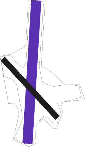
Runway info
| Runway 17 / 35 | ||
| length | 1519m (4984ft) | |
| bearing | 190° / 10° | |
| width | 110m (361ft) | |
| surface | grass | |
Runway 13 / 31  | ||
| length | 853m (2799ft) | |
| bearing | 136° / 316° | |
| width | 62m (203ft) | |
| surface | grass | |
Nearby beacons
| code | identifier | dist | bearing | frequency |
|---|---|---|---|---|
| KK | KERIKERI NDB | 12.2 | 26° | 226 |
| WR | WHANGAREI NDB | 32.8 | 120° | 326 |
| SF | SPRINGFIELD (WHANGAREI) NDB | 37 | 129° | 366 |
| KT | KAITAIA NDB | 37.9 | 306° | 238 |
Disclaimer
The information on this website is not for real aviation. Use this data with the X-Plane flight simulator only! Data taken with kind consent from X-Plane 12 source code and data files. Content is subject to change without notice.