Pokeno - Mercer
Airport details
| Country | New Zealand |
| State | Waikato |
| Region | NZ |
| Municipality | Waikato District |
| Elevation | 65ft (20m) |
| Timezone | GMT +13 |
| Coordinates | -37.25750, 175.11501 |
| Magnetic var | |
| Type | land |
| Available since | X-Plane v10.40 |
| ICAO code | NZME |
| IATA code | n/a |
| FAA code | n/a |
Communication
| Mercer MERCER AWOS | 133.050 |
| Mercer MERCER MULT | 133.050 |
| Mercer AUCKLAND Approach | 124.300 |
Nearby Points of Interest:
Firth of Thames
-Chapel of St John the Evangelist, Auckland
-Pah Homestead
-Stoneways
-Albert Barracks Wall
-Auckland Town Hall
-Auckland Savings Bank Building
-Kenneth Myers Centre
-Bluestone Store
-Dilworth Building
-Gluepot Tavern
-Auckland volcanic field
-Fairfield Bridge
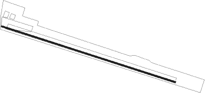
Runway info
| Runway 09 / 27 | ||
| length | 1318m (4324ft) | |
| bearing | 108° / 288° | |
| width | 10m (33ft) | |
| surface | asphalt | |
| displ threshold | 40m (131ft) / 225m (738ft) | |
Nearby beacons
| code | identifier | dist | bearing | frequency |
|---|---|---|---|---|
| SY | SURREY NDB | 2.7 | 70° | 350 |
| WI | WAIUKU NDB | 14.3 | 268° | 254 |
| AA | AUCKLAND VOR/DME | 20.9 | 310° | 114.80 |
| WP | WHENUAPAI (AUCKLAND) VOR/DME | 36.5 | 314° | 116.40 |
| HN | HAMILTON VOR/DME | 37 | 159° | 114 |
| CV | CUVIER I. NDB | 58.5 | 39° | 302 |
Disclaimer
The information on this website is not for real aviation. Use this data with the X-Plane flight simulator only! Data taken with kind consent from X-Plane 12 source code and data files. Content is subject to change without notice.