Martins Bay
Airport details
| Country | New Zealand |
| State | Southland |
| Region | NZ |
| Municipality | Fiordland Community |
| Elevation | 19ft (6m) |
| Timezone | GMT +13 |
| Coordinates | -44.36361, 168.01917 |
| Magnetic var | |
| Type | land |
| Available since | X-Plane v10.40 |
| ICAO code | NZMJ |
| IATA code | n/a |
| FAA code | n/a |
Communication
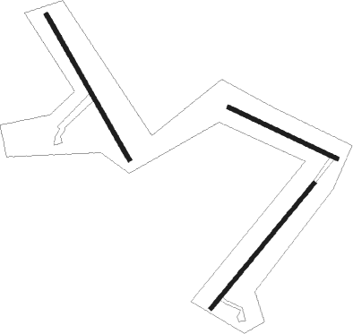
Runway info
Runway 06 / 24  | ||
| length | 577m (1893ft) | |
| bearing | 53° / 233° | |
| width | 15m (49ft) | |
| surface | grass | |
| Runway 14 / 32 | ||
| length | 426m (1398ft) | |
| bearing | 112° / 292° | |
| width | 15m (49ft) | |
| surface | grass | |
| Runway 17 / 35 | ||
| length | 596m (1955ft) | |
| bearing | 147° / 327° | |
| width | 15m (49ft) | |
| surface | grass | |
Nearby beacons
| code | identifier | dist | bearing | frequency |
|---|---|---|---|---|
| QN | QUEENSTOWN VOR/DME | 49.5 | 129° | 113.60 |
Disclaimer
The information on this website is not for real aviation. Use this data with the X-Plane flight simulator only! Data taken with kind consent from X-Plane 12 source code and data files. Content is subject to change without notice.