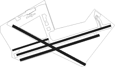
Masterton - Hood Aerodrome
Airport details
| Country | New Zealand |
| State | Wellington |
| Region | NZ |
| Municipality | Masterton District |
| Elevation | 350ft (107m) |
| Timezone | GMT +12 |
| Coordinates | -40.97333, 175.63361 |
| Magnetic var | |
| Type | land |
| Available since | X-Plane v10.40 |
| ICAO code | NZMS |
| IATA code | MRO |
| FAA code | n/a |
Communication
| Hood Aerodrome MASTERTON AWOS | 132.800 |
| Hood Aerodrome CHRISTCHURCH FSS | 124.200 |
| Hood Aerodrome MASTERTON MULT | 119.100 |
| Hood Aerodrome OHAKEA Approach | 126.700 |
Nearby Points of Interest:
Brancepeth Station
-Featherston Prisoner of War Camp
-Longwood
-Carkeek Observatory
Runway info
Nearby beacons
| code | identifier | dist | bearing | frequency |
|---|---|---|---|---|
| PP | PARAPARAUMU NDB | 29.8 | 276° | 242 |
| PM | PALMERSTON NORTH VOR/DME | 39.2 | 0° | 113.40 |
| NL | NEWLANDS (WELLINGTON) NDB | 39.5 | 252° | 358 |
| WN | WELLINGTON VOR/DME | 42.9 | 246° | 112.30 |
| OH | OHAKEA VOR/DME | 47.1 | 342° | 117.10 |
Departure and arrival routes
| Transition altitude | 13000ft |
| Transition level | 15000ft |
| SID end points | distance | outbound heading | |
|---|---|---|---|
| RW06 | |||
| URDA4B | 59mi | 48° | |
| LADI3B | 19mi | 259° | |
| RW24 | |||
| URDA4A | 59mi | 48° | |
| LADI3A | 19mi | 259° | |
| STAR starting points | distance | inbound heading | |
|---|---|---|---|
| RW06 | |||
| MAMO06 | 12.8 | 43° | |
| RW24 | |||
| URDA24 | 11.4 | 239° | |
| ATVO24 | 11.5 | 280° | |
Instrument approach procedures
| runway | airway (heading) | route (dist, bearing) |
|---|---|---|
| RW06 | MAMOD (43°) | MAMOD 3700ft MS603 (5mi, 10°) 3050ft |
| RNAV | MS603 3050ft MS488 (5mi, 45°) 1550ft MS818 (3mi, 72°) 643ft SADUN (11mi, 80°) 3800ft | |
| RW24 | ATVOX (280°) | ATVOX SADUN (5mi, 343°) 3300ft |
| RW24 | SADUN (261°) | SADUN 3800ft |
| RW24 | URDAL (239°) | URDAL SADUN (5mi, 163°) 3300ft |
| RNAV | SADUN 3300ft MS402 (4mi, 260°) 2200ft MS572 (6mi, 260°) 383ft (8338mi, 283°) 1400ft SADUN (8341mi, 103°) 3800ft |
Disclaimer
The information on this website is not for real aviation. Use this data with the X-Plane flight simulator only! Data taken with kind consent from X-Plane 12 source code and data files. Content is subject to change without notice.

