Oamaru
Airport details
| Country | New Zealand |
| State | Canterbury |
| Region | NZ |
| Municipality | Waitaki District |
| Elevation | 99ft (30m) |
| Timezone | GMT +12 |
| Coordinates | -44.97167, 171.08167 |
| Magnetic var | |
| Type | land |
| Available since | X-Plane v10.40 |
| ICAO code | NZOU |
| IATA code | OAM |
| FAA code | n/a |
Communication
| Oamaru CTAF | 119.100 |
Nearby Points of Interest:
Waitaki District Council building
-Oamaru Harbour Board Office (Former)
-AMP Society Building
-AH Maude's Stores
-Union Offices (Former)
-Smith's Grain Store
-Band Rotunda (Oamaru Public Gardens)
-Exchange Chambers (Former)
-Anderson and Co. Flour and Grain Merchants' Store (Former)
-Totara Estate
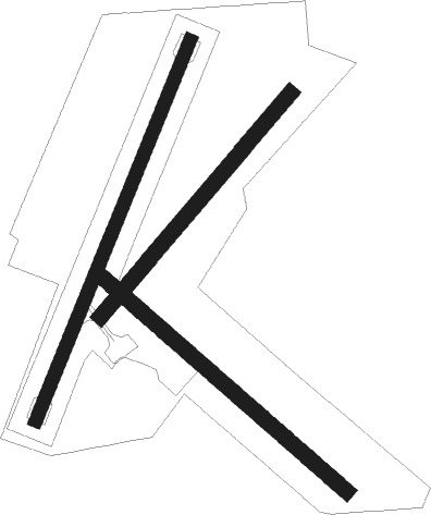
Runway info
Runway 18 / 36  | ||
| length | 1278m (4193ft) | |
| bearing | 215° / 35° | |
| width | 40m (131ft) | |
| surface | concrete | |
| Runway 11 / 29 | ||
| length | 1006m (3301ft) | |
| bearing | 126° / 306° | |
| width | 50m (164ft) | |
| surface | dirt | |
| Runway 02 / 20 | ||
| length | 911m (2989ft) | |
| bearing | 55° / 235° | |
| width | 50m (164ft) | |
| surface | dirt | |
Nearby beacons
| code | identifier | dist | bearing | frequency |
|---|---|---|---|---|
| OU | OAMARU NDB | 2.6 | 64° | 302 |
| TU | TIMARU NDB | 40.3 | 12° | 366 |
| SW | SWAMPY (DUNEDIN) VOR/DME | 55.6 | 216° | 112.70 |
| RY | MARY DME | 60.8 | 316° | 112.50 |
| MI | MOSGIEL NDB | 62.8 | 220° | 358 |
| HL | HENLEY (DUNEDIN) NDB | 70.1 | 223° | 378 |
Instrument approach procedures
| runway | airway (heading) | route (dist, bearing) |
|---|---|---|
| RW18 | AMOKO (181°) | AMOKO PAMOA (5mi, 110°) 2000ft |
| RW18 | PAMOA (214°) | PAMOA 2000ft |
| RW18 | SAMBU (240°) | SAMBU PAMOA (5mi, 290°) 2000ft |
| RNAV | PAMOA 2000ft FF18 (5mi, 215°) 1650ft NZOU (6mi, 214°) 142ft PAMOA (11mi, 34°) 2000ft | |
| RW36 | ALMAN (1°) | ALMAN ORBEL (5mi, 290°) 2000ft |
| RW36 | KAURU (62°) | KAURU ORBEL (5mi, 110°) 2000ft |
| RW36 | ORBEL (36°) | ORBEL 3400ft |
| RNAV | ORBEL 2000ft FF36 (5mi, 35°) 1650ft NZOU (5mi, 37°) 147ft ORBEL (10mi, 216°) 3400ft |
Disclaimer
The information on this website is not for real aviation. Use this data with the X-Plane flight simulator only! Data taken with kind consent from X-Plane 12 source code and data files. Content is subject to change without notice.