Rangiora
Airport details
| Country | New Zealand |
| State | Canterbury |
| Region | NZ |
| Municipality | Waimakariri District |
| Elevation | 179ft (55m) |
| Timezone | GMT +13 |
| Coordinates | -43.28770, 172.54208 |
| Magnetic var | |
| Type | land |
| Available since | X-Plane v10.40 |
| ICAO code | NZRT |
| IATA code | n/a |
| FAA code | n/a |
Communication
| Rangiora RANGIORA MULT | 119.200 |
Nearby Points of Interest:
Papanui Railway Station
-Chippenham Lodge
-St Barnabas Church
-St Andrew's Church
-Daresbury
-Riccarton House
-McLean's Mansion
-Antonio Hall
-Victoria Mansions
-Peterborough Centre
-Wharetiki
-St Luke's Church, Christchurch
-Durham Street Methodist Church
-Cranmer Centre
-Christ's College Big School
-Canterbury Provincial Council Buildings
-New Regent Street
-Worcester Chambers
-Registry Building
-Canterbury Club
-St Elmo Courts
-The Press Building, Christchurch
-Canterbury Cricket Umpires' Association Pavilion
-Public Trust Building, Christchurch
-Old Government Building, Christchurch
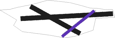
Runway info
Runway 07 / 25  | ||
| length | 1173m (3848ft) | |
| bearing | 91° / 271° | |
| width | 60m (197ft) | |
| surface | grass | |
| Runway 10 / 28 | ||
| length | 696m (2283ft) | |
| bearing | 116° / 296° | |
| width | 60m (197ft) | |
| surface | grass | |
| Runway 04 / 22 | ||
| length | 518m (1699ft) | |
| bearing | 64° / 244° | |
| width | 35m (115ft) | |
| surface | grass | |
Nearby beacons
| code | identifier | dist | bearing | frequency |
|---|---|---|---|---|
| CH | CHRISTCHURCH VOR/DME | 13 | 187° | 115.30 |
Disclaimer
The information on this website is not for real aviation. Use this data with the X-Plane flight simulator only! Data taken with kind consent from X-Plane 12 source code and data files. Content is subject to change without notice.