Stratford
Airport details
| Country | New Zealand |
| State | Manawatū-Whanganui |
| Region | NZ |
| Municipality | Stratford District |
| Elevation | 944ft (288m) |
| Timezone | GMT +13 |
| Coordinates | -39.31889, 174.31027 |
| Magnetic var | |
| Type | land |
| Available since | X-Plane v10.40 |
| ICAO code | NZSD |
| IATA code | n/a |
| FAA code | n/a |
Communication
Nearby Points of Interest:
The Taranaki Cathedral Church of St Mary
-Cape Egmont Lighthouse
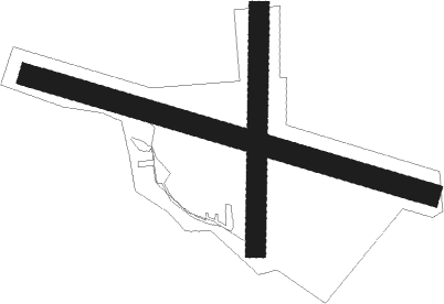
Runway info
Runway 09 / 27  | ||
| length | 934m (3064ft) | |
| bearing | 107° / 287° | |
| width | 50m (164ft) | |
| surface | grass | |
| Runway 16 / 34 | ||
| length | 531m (1742ft) | |
| bearing | 187° / 7° | |
| width | 45m (148ft) | |
| surface | grass | |
Nearby beacons
| code | identifier | dist | bearing | frequency |
|---|---|---|---|---|
| NP | NEW PLYMOUTH VOR/DME | 19.6 | 338° | 114.40 |
| OR | DME | 37.5 | 45° | 113 |
| WU | WHANGANUI NDB | 50.7 | 132° | 382 |
Disclaimer
The information on this website is not for real aviation. Use this data with the X-Plane flight simulator only! Data taken with kind consent from X-Plane 12 source code and data files. Content is subject to change without notice.