Takaka
Airport details
| Country | New Zealand |
| State | Tasman |
| Region | NZ |
| Elevation | 82ft (25m) |
| Timezone | GMT +12 |
| Coordinates | -40.81333, 172.77528 |
| Magnetic var | |
| Type | land |
| Available since | X-Plane v10.40 |
| ICAO code | NZTK |
| IATA code | KTF |
| FAA code | n/a |
Communication
Nearby Points of Interest:
Farewell Spit
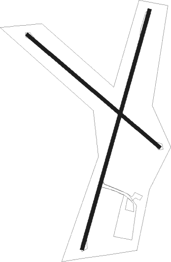
Runway info
Runway 18 / 36  | ||
| length | 820m (2690ft) | |
| bearing | 206° / 26° | |
| width | 12m (40ft) | |
| surface | asphalt | |
| displ threshold | 30m (98ft) / 67m (220ft) | |
| Runway 12 / 30 | ||
| length | 574m (1883ft) | |
| bearing | 127° / 307° | |
| width | 12m (40ft) | |
| surface | gravel | |
Nearby beacons
| code | identifier | dist | bearing | frequency |
|---|---|---|---|---|
| NS | NELSON VOR/DME | 35.5 | 138° | 113.10 |
Departure and arrival routes
| Transition altitude | 13000ft |
| Transition level | 15000ft |
| SID end points | distance | outbound heading | |
|---|---|---|---|
| RW36 | |||
| MARKO3 | 12mi | 52° | |
Instrument approach procedures
| runway | airway (heading) | route (dist, bearing) |
|---|---|---|
| RW18-Y | MARKO (232°) | MARKO TK401 (5mi, 270°) 2500ft |
| RNAV | TK401 2500ft BENVU (4mi, 206°) 1720ft TK407 (4mi, 206°) 449ft MARKO (11mi, 54°) 2500ft MARKO (turn) 2500ft | |
| RW18-Z | MARKO (232°) | MARKO TK401 (5mi, 270°) 2500ft |
| RNAV | TK401 2500ft BENVU (4mi, 206°) 1720ft TK407 (4mi, 206°) 449ft MARKO (11mi, 54°) 2500ft MARKO (turn) 2500ft |
Disclaimer
The information on this website is not for real aviation. Use this data with the X-Plane flight simulator only! Data taken with kind consent from X-Plane 12 source code and data files. Content is subject to change without notice.