Timaru
Airport details
| Country | New Zealand |
| State | Canterbury |
| Region | NZ |
| Municipality | Timaru District |
| Elevation | 88ft (27m) |
| Timezone | GMT +12 |
| Coordinates | -44.30278, 171.22528 |
| Magnetic var | |
| Type | land |
| Available since | X-Plane v10.40 |
| ICAO code | NZTU |
| IATA code | TIU |
| FAA code | n/a |
Communication
| Timaru CTAF | 119.500 |
Runway info
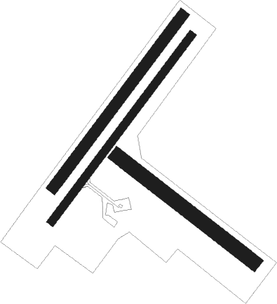
Runway 02 / 20  | ||
| length | 1279m (4196ft) | |
| bearing | 51° / 231° | |
| width | 45m (148ft) | |
| surface | asphalt | |
| Runway 02L / 20R | ||
| length | 1184m (3885ft) | |
| bearing | 51° / 231° | |
| width | 60m (197ft) | |
| surface | grass | |
| Runway 11 / 29 | ||
| length | 948m (3110ft) | |
| bearing | 123° / 303° | |
| width | 80m (262ft) | |
| surface | grass | |
| displ threshold | 0m (0ft) / 77m (253ft) | |
Nearby beacons
| code | identifier | dist | bearing | frequency |
|---|---|---|---|---|
| TU | TIMARU NDB | 0.3 | 182° | 366 |
| OU | OAMARU NDB | 38.9 | 188° | 302 |
| RY | MARY DME | 41.8 | 280° | 112.50 |
Departure and arrival routes
| Transition altitude | 13000ft |
| Transition level | 15000ft |
| SID end points | distance | outbound heading | |
|---|---|---|---|
| RW02 | |||
| BIDN1P | 41mi | 192° | |
| RW20 | |||
| MUKE1Q | 41mi | 192° | |
| STAR starting points | distance | inbound heading | |
|---|---|---|---|
| RW02 | |||
| PORU2J | 90.7 | 64° | |
| MAMU2J | 41.8 | 100° | |
| DUBO2J | 49.4 | 162° | |
| ELDA1J | 33.6 | 236° | |
| RW20 | |||
| DOPO1K | 13.5 | 8° | |
| PORU1K | 90.7 | 64° | |
| MAMU1K | 41.8 | 100° | |
| DUBO1K | 49.4 | 162° | |
| ELDA1K | 33.6 | 236° | |
Instrument approach procedures
| runway | airway (heading) | route (dist, bearing) |
|---|---|---|
| RW02 | DOPOP (8°) | DOPOP TU593 (4mi, 302°) 2500ft |
| RNAV | TU593 2500ft REKID (5mi, 16°) 2280ft TU402 (6mi, 35°) 371ft (8108mi, 285°) 1000ft DOPOP (8095mi, 105°) 2500ft DOPOP (turn) 2500ft | |
| RW20 | BIDNI (256°) | BIDNI SUNPA (5mi, 302°) 2000ft |
| RW20 | LUVAB (194°) | LUVAB SUNPA (5mi, 122°) 2000ft |
| RNAV | SUNPA 2000ft EMTEP (5mi, 231°) 1090ft NZTU (4mi, 229°) 135ft (8109mi, 285°) 1000ft BIDNI (8114mi, 104°) 2000ft BIDNI (turn) 2000ft |
Holding patterns
| STAR name | hold at | type | turn | heading* | altitude | leg | speed limit |
|---|---|---|---|---|---|---|---|
| DOPO1K | BIDNI | VHF | left | 107 (287)° | > 2000ft | 1.0min timed | ICAO rules |
| DUBO2J | DOPOP | VHF | right | 107 (287)° | > 2500ft | 1.0min timed | ICAO rules |
| ELDA1J | DOPOP | VHF | right | 107 (287)° | > 2500ft | 1.0min timed | ICAO rules |
| ELDA1K | BIDNI | VHF | left | 107 (287)° | > 2000ft | 1.0min timed | ICAO rules |
| MAMU2J | DOPOP | VHF | right | 107 (287)° | > 2500ft | 1.0min timed | ICAO rules |
| PORU2J | DOPOP | VHF | right | 107 (287)° | > 2500ft | 1.0min timed | ICAO rules |
| *) magnetic outbound (inbound) holding course | |||||||
Disclaimer
The information on this website is not for real aviation. Use this data with the X-Plane flight simulator only! Data taken with kind consent from X-Plane 12 source code and data files. Content is subject to change without notice.