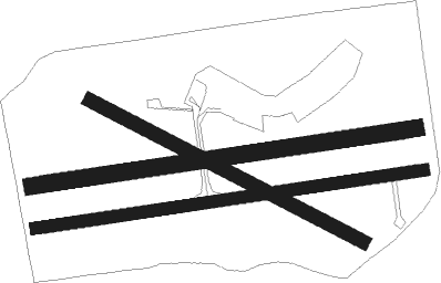
Blenheim - Woodbourne
Airport details
| Country | New Zealand |
| State | Marlborough |
| Region | NZ |
| Elevation | 107ft (33m) |
| Timezone | GMT +12 |
| Coordinates | -41.51833, 173.87029 |
| Magnetic var | |
| Type | land |
| Available since | X-Plane v10.40 |
| ICAO code | NZWB |
| IATA code | BHE |
| FAA code | n/a |
Communication
| Woodbourne ATIS | 128.200 |
| Woodbourne CTAF | 122.800 |
| Woodbourne Tower | 118.100 |
| Woodbourne Tower | 122.800 |
| Woodbourne WELLINGTON Approach | 119.300 |
| Woodbourne WELLINGTON Approach | 126.500 |
| Woodbourne WELLINGTON Approach | 121.100 |
| Woodbourne WELLINGTON Approach | 122.300 |
Nearby beacons
| code | identifier | dist | bearing | frequency |
|---|---|---|---|---|
| WB | WOODBOURNE VOR/DME | 0.3 | 260° | 115.60 |
| BM | DME | 7.3 | 85° | 117.90 |
| TR | DME | 29.8 | 56° | 114.60 |
| NS | NELSON VOR/DME | 32.1 | 288° | 113.10 |
| WN | WELLINGTON VOR/DME | 43.9 | 79° | 112.30 |
| NL | NEWLANDS (WELLINGTON) NDB | 46.5 | 73° | 358 |
| KI | KAIKOURA NDB | 54.7 | 191° | 350 |
Departure and arrival routes
| Transition altitude | 13000ft |
| Transition level | 15000ft |
| SID end points | distance | outbound heading | |
|---|---|---|---|
| RW06 | |||
| SEDS2Q | 22mi | 56° | |
| DOTU2Q | 20mi | 92° | |
| RW24 | |||
| BODI2P | 20mi | 92° | |
| STAR starting points | distance | inbound heading | |
|---|---|---|---|
| RW06 | |||
| AVPO1K, AVPO1M | 24.2 | 247° | |
| SUPE2M, SUPE2K | 15.1 | 254° | |
| IGMU1M, IGMU1K | 23.2 | 262° | |
| JAMI2K, JAMI2M | 15.4 | 280° | |
| RW24 | |||
| AVPO1J | 24.2 | 247° | |
| SUPE2J | 15.1 | 254° | |
| IGMU1J | 23.2 | 262° | |
| JAMI2J | 15.4 | 280° | |
Instrument approach procedures
| runway | airway (heading) | route (dist, bearing) |
|---|---|---|
| RW24 | LUTKA (266°) | LUTKA 3000ft |
| RNAV | LUTKA 3000ft ELKUB (5mi, 266°) 3000ft ENPIP (5mi, 266°) 1400ft WB401 (4mi, 266°) 224ft BEMAL (9mi, 267°) TURPO (9mi, 98°) 3000ft BODIM (7mi, 97°) JAMIE (8mi, 91°) LUTKA (5mi, 352°) 4000ft LUTKA (turn) 4000ft |
Disclaimer
The information on this website is not for real aviation. Use this data with the X-Plane flight simulator only! Data taken with kind consent from X-Plane 12 source code and data files. Content is subject to change without notice.

