Wanganui
Airport details
| Country | New Zealand |
| State | Manawatū-Whanganui |
| Region | NZ |
| Municipality | Whanganui |
| Elevation | 24ft (7m) |
| Timezone | GMT +12 |
| Coordinates | -39.96222, 175.02528 |
| Magnetic var | |
| Type | land |
| Available since | X-Plane v10.40 |
| ICAO code | NZWU |
| IATA code | WAG |
| FAA code | n/a |
Communication
| Wanganui CTAF | 120.200 |
| Wanganui OHAKEA CON | 120.400 |
Nearby Points of Interest:
Durie Hill Elevator
-Cameron Blockhouse
-Bushy Park Homestead
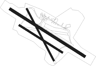
Runway info
Runway 11 / 29  | ||
| length | 1371m (4498ft) | |
| bearing | 120° / 300° | |
| width | 45m (148ft) | |
| surface | asphalt | |
| Runway 14 / 32 | ||
| length | 912m (2992ft) | |
| bearing | 151° / 331° | |
| width | 30m (98ft) | |
| surface | dirt | |
| blast zone | 0m (0ft) / 62m (203ft) | |
| Runway 11R / 29L | ||
| length | 789m (2589ft) | |
| bearing | 120° / 300° | |
| width | 32m (105ft) | |
| surface | dirt | |
| displ threshold | 60m (197ft) / 0m (0ft) | |
Nearby beacons
| code | identifier | dist | bearing | frequency |
|---|---|---|---|---|
| WU | WHANGANUI NDB | 0.1 | 23° | 382 |
| WU | DME | 0.2 | 18° | 116 |
| OH | OHAKEA VOR/DME | 22.4 | 124° | 117.10 |
| PM | PALMERSTON NORTH VOR/DME | 35.4 | 120° | 113.40 |
| PP | PARAPARAUMU NDB | 56.5 | 183° | 242 |
| NP | NEW PLYMOUTH VOR/DME | 69.3 | 319° | 114.40 |
Departure and arrival routes
| Transition altitude | 13000ft |
| Transition level | 15000ft |
| STAR starting points | distance | inbound heading | |
|---|---|---|---|
| RW11 | |||
| TENU1M | 20.2 | 196° | |
| VIRO2M | 11.3 | 346° | |
| RW29 | |||
| TENU1L | 20.2 | 196° | |
| VIRO1L | 11.3 | 346° | |
Instrument approach procedures
| runway | airway (heading) | route (dist, bearing) |
|---|---|---|
| RW11 | AVLOR (97°) | AVLOR DUDED (5mi, 44°) 2200ft |
| RW11 | BUPKA (148°) | BUPKA DUDED (5mi, 224°) 2200ft |
| RW11 | DUDED (120°) | DUDED 2700ft |
| RNAV | DUDED 2200ft FF11 (4mi, 120°) 1490ft NZWU (5mi, 119°) 60ft (8395mi, 283°) 1000ft DUDED (8399mi, 103°) 2700ft DUDED (turn) 2700ft | |
| RW29 | ADGAT (279°) | ADGAT BASEP (4mi, 224°) 2000ft |
| RW29 | BELVO (326°) | BELVO BASEP (4mi, 44°) 2000ft |
| RNAV | BASEP 2000ft BUSBI (4mi, 300°) 1350ft NZWU (4mi, 301°) 76ft DUDED (9mi, 300°) 2700ft DUDED (turn) 2700ft |
Holding patterns
| STAR name | hold at | type | turn | heading* | altitude | leg | speed limit |
|---|---|---|---|---|---|---|---|
| TENU1L | ADGAT | VHF | right | 15 (195)° | > 2700ft | 1.0min timed | ICAO rules |
| *) magnetic outbound (inbound) holding course | |||||||
Disclaimer
The information on this website is not for real aviation. Use this data with the X-Plane flight simulator only! Data taken with kind consent from X-Plane 12 source code and data files. Content is subject to change without notice.