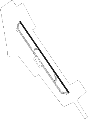
Jizan - King Abdullah Bin Abdulaziz
Airport details
| Country | Saudi Arabia |
| State | Jazan Province |
| Region | OE |
| Airspace | Jeddah Ctr |
| Municipality | Jizan |
| Elevation | 20ft (6m) |
| Timezone | GMT +3 |
| Coordinates | 16.90108, 42.58577 |
| Magnetic var | |
| Type | land |
| Available since | X-Plane v10.40 |
| ICAO code | OEGN |
| IATA code | GIZ |
| FAA code | n/a |
Communication
| King Abdullah bin Abdulaziz Ground Control | 121.900 |
| King Abdullah bin Abdulaziz JAZAN Tower | 118.000 |
Approach frequencies
| ILS-cat-I | RW33 | 109.9 | 18.00mi |
| 3° GS | RW33 | 109.9 | 18.00mi |
Runway info
| Runway 15 / 33 | ||
| length | 3062m (10046ft) | |
| bearing | 149° / 329° | |
| width | 45m (148ft) | |
| surface | asphalt | |
| blast zone | 255m (837ft) / 255m (837ft) | |
Nearby beacons
| code | identifier | dist | bearing | frequency |
|---|---|---|---|---|
| GIZ | JAZAN VOR/DME | 0.6 | 309° | 117.70 |
Instrument approach procedures
| runway | airway (heading) | route (dist, bearing) |
|---|---|---|
| RW15 | DINAS (149°) | DINAS JAZA2 (19mi, 148°) 2500ft RAKID (5mi, 149°) 1700ft |
| RW15 | JAZA2 (149°) | JAZA2 2500ft RAKID (5mi, 149°) 1700ft |
| RW15 | KIROM (214°) | KIROM JAZA2 (27mi, 236°) 2500ft RAKID (5mi, 149°) 1700ft |
| RW15 | LUBAL (134°) | LUBAL JAZA2 (20mi, 125°) 2500ft RAKID (5mi, 149°) 1700ft |
| RW15 | MUVOP (92°) | MUVOP JAZA2 (26mi, 71°) 2500ft RAKID (5mi, 149°) 1700ft |
| RW15 | PEKAR (183°) | PEKAR JAZA2 (22mi, 199°) 2500ft RAKID (5mi, 149°) 1700ft |
| RNAV | RAKID 1700ft JAZA4 (5mi, 149°) 66ft JAZA4 (turn) 1500ft JAZA2 (11mi, 329°) 2500ft JAZA2 (turn) 2500ft | |
| RW33 | BUDAD (329°) | BUDAD 2000ft |
| RW33 | DINAS (149°) | DINAS BUDAD (37mi, 149°) 2500ft BUDAD (turn) 2000ft |
| RW33 | KIROM (214°) | KIROM BUDAD (33mi, 205°) 2500ft BUDAD (turn) 2000ft |
| RW33 | LUBAL (134°) | LUBAL BUDAD (36mi, 136°) 2500ft BUDAD (turn) 2000ft |
| RW33 | MUVOP (92°) | MUVOP BUDAD (34mi, 100°) 2500ft BUDAD (turn) 2000ft |
| RW33 | PEKAR (183°) | PEKAR BUDAD (36mi, 177°) 2500ft BUDAD (turn) 2000ft |
| RNAV | BUDAD 1700ft JAZA6 (5mi, 329°) 72ft JAZA6 (turn) 1000ft BUDAD (5mi, 149°) 2000ft BUDAD (turn) 2000ft |
Disclaimer
The information on this website is not for real aviation. Use this data with the X-Plane flight simulator only! Data taken with kind consent from X-Plane 12 source code and data files. Content is subject to change without notice.
