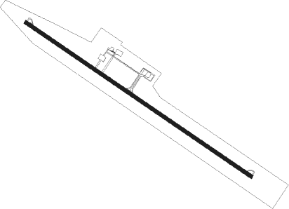
Jiroft
Airport details
| Country | Iran |
| State | Kerman Province |
| Region | OI |
| Airspace | Tehran Ctr |
| Municipality | دهستان هلیل |
| Elevation | 2663ft (812m) |
| Timezone | GMT +3.5 |
| Coordinates | 28.72750, 57.67028 |
| Magnetic var | |
| Type | land |
| Available since | X-Plane v10.40 |
| ICAO code | OIKJ |
| IATA code | JYR |
| FAA code | n/a |
Communication
| Jiroft INFO | 128.200 |
Nearby beacons
| code | identifier | dist | bearing | frequency |
|---|---|---|---|---|
| JIR | JIROFT NDB | 0.2 | 26° | 276 |
| BAM | BAM NDB | 46.2 | 66° | 379 |
| BAM | BAM VOR/DME | 46.4 | 66° | 114.90 |
Departure and arrival routes
| Transition altitude | 10000ft |
| Transition level | 12000ft |
| SID end points | distance | outbound heading | |
|---|---|---|---|
| RW13 | |||
| PEDU1A | 20mi | 43° | |
| RIGU1A | 20mi | 236° | |
| STAR starting points | distance | inbound heading | |
|---|---|---|---|
| ALL | |||
| RIGU1N | 19.7 | 56° | |
| PEDU1N | 20.2 | 223° | |
Instrument approach procedures
| runway | airway (heading) | route (dist, bearing) |
|---|---|---|
| RW31 | KJ403 (325°) | KJ403 8000ft KJ402 (5mi, 42°) 6500ft |
| RNAV | KJ402 6500ft KJ401 (5mi, 305°) 5400ft OIKJ (9mi, 305°) 2575ft KJ404 (turn) 2575ft KJ405 (5mi, 201°) 5000ft KJ403 (13mi, 125°) 8000ft KJ403 (turn) 8000ft |
Disclaimer
The information on this website is not for real aviation. Use this data with the X-Plane flight simulator only! Data taken with kind consent from X-Plane 12 source code and data files. Content is subject to change without notice.
