Mashhad - Mashhad Intl
Airport details
| Country | Iran |
| State | Razavi Khorasan |
| Region | OI |
| Airspace | Tehran Ctr |
| Municipality | Mashhad |
| Elevation | 3266ft (995m) |
| Timezone | GMT +3.5 |
| Coordinates | 36.23417, 59.64500 |
| Magnetic var | |
| Type | land |
| Available since | X-Plane v10.40 |
| ICAO code | OIMM |
| IATA code | MHD |
| FAA code | n/a |
Communication
| Mashhad intl ATIS | 126.400 |
| Mashhad intl Ground Control | 121.700 |
| Mashhad intl Tower | 118.100 |
| Mashhad intl Tower | 121.900 |
| Mashhad intl Approach | 127.300 |
Approach frequencies
| ILS-cat-I | RW31R | 109.9 | 18.00mi |
| 3° GS | RW31R | 109.9 | 18.00mi |
Nearby Points of Interest:
Baba Qodrat Caravanserai
-Imam Reza Shrine
-Dodar Madrasa
-Mehdi Qoli Beyk Hammam
-Shah Mosque (Mashhad)
-Behesht Cultural Center (Mashhad)
-Darougheh House
-Malek House, Mashhad
-Azizollahov House
-Ghafouri House
-Akhangan Tower
-Shir Qal'eh
-Bazeh Hur Chahartaq
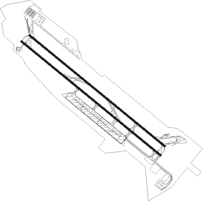
Runway info
Runway 13L / 31R  | ||
| length | 3809m (12497ft) | |
| bearing | 128° / 308° | |
| width | 45m (148ft) | |
| surface | asphalt | |
| blast zone | 255m (837ft) / 255m (837ft) | |
| Runway 13R / 31L | ||
| length | 3919m (12858ft) | |
| bearing | 128° / 308° | |
| width | 45m (148ft) | |
| surface | asphalt | |
| blast zone | 255m (837ft) / 255m (837ft) | |
Nearby beacons
| code | identifier | dist | bearing | frequency |
|---|---|---|---|---|
| MSD | MASHHAD VOR/DME | 0.3 | 118° | 114 |
| MSD | MASHHAD NDB | 0.4 | 232° | 385 |
Departure and arrival routes
| Transition altitude | 8000ft |
| SID end points | distance | outbound heading | |
|---|---|---|---|
| RW13 (ALL) | |||
| PAMT1J, PAMT1H, PAMT1D, PAMT1C | 97mi | 126° | |
| NOTS1K, NOTS1D, NOTS1E, NOTS1J | 60mi | 188° | |
| LOSA1B | 60mi | 212° | |
| RAMI1K, RAMI1E | 60mi | 228° | |
| EMES1B | 60mi | 247° | |
| ORDO1C | 59mi | 272° | |
| BOTE1E, BOTE1K | 60mi | 299° | |
| MIDM1E, MIDM1K | 60mi | 324° | |
| RW31 (ALL) | |||
| PAMT1A, PAMT1B, PAMT1F, PAMT1G | 97mi | 126° | |
| NOTS1A, NOTS1F | 60mi | 188° | |
| LOSA1A | 60mi | 212° | |
| RAMI1A, RAMI1F | 60mi | 228° | |
| EMES1A | 60mi | 247° | |
| ORDO1A, ORDO1B | 59mi | 272° | |
| BOTE1A, BOTE1F | 60mi | 299° | |
| MIDM1F, MIDM1A | 60mi | 324° | |
| STAR starting points | distance | inbound heading | |
|---|---|---|---|
| ALL | |||
| NOTS1N | 60.2 | 8° | |
| LOSA1N | 60.0 | 32° | |
| RAMI1N | 60.0 | 48° | |
| EMES1N | 59.6 | 67° | |
| RIBU1N | 59.5 | 80° | |
| BOTE1N | 59.7 | 119° | |
| MIDM1N | 59.7 | 144° | |
| PAMT1T, PAMT1R, PAMT1N | 96.8 | 306° | |
| RW13 (ALL) | |||
| LOSA1Q | 60.0 | 32° | |
| RAMI1Q | 60.0 | 48° | |
| EMES1Q | 59.6 | 67° | |
| RIBU1Q | 59.5 | 80° | |
| BOTE1Q | 59.7 | 119° | |
| MIDM1Q | 59.7 | 144° | |
| RW31 (ALL) | |||
| NOTS1R, NOTS1P | 60.2 | 8° | |
| LOSA1P | 60.0 | 32° | |
| RAMI1P, RAMI1R | 60.0 | 48° | |
| EMES1P | 59.6 | 67° | |
| RIBU1P | 59.5 | 80° | |
| PAMT1P | 96.8 | 306° | |
Holding patterns
| STAR name | hold at | type | turn | heading* | altitude | leg | speed limit |
|---|---|---|---|---|---|---|---|
| BOTE1Q | D309Q | VHF | left | 309 (129)° | > 8000ft | 1.0min timed | ICAO rules |
| EMES1P | D134P | VHF | right | 134 (314)° | > 8000ft | 1.0min timed | ICAO rules |
| EMES1Q | D309Q | VHF | left | 309 (129)° | > 8000ft | 1.0min timed | ICAO rules |
| LOSA1P | D134P | VHF | right | 134 (314)° | > 8000ft | 1.0min timed | ICAO rules |
| LOSA1Q | D309Q | VHF | left | 309 (129)° | > 8000ft | 1.0min timed | ICAO rules |
| MIDM1Q | D309Q | VHF | left | 309 (129)° | > 8000ft | 1.0min timed | ICAO rules |
| NOTS1P | D134P | VHF | right | 134 (314)° | > 8000ft | 1.0min timed | ICAO rules |
| NOTS1R | D134P | VHF | right | 134 (314)° | > 8000ft | 1.0min timed | ICAO rules |
| PAMT1P | D134P | VHF | right | 134 (314)° | > 8000ft | 1.0min timed | ICAO rules |
| RAMI1P | D134P | VHF | right | 134 (314)° | > 8000ft | 1.0min timed | ICAO rules |
| RAMI1Q | D309Q | VHF | left | 309 (129)° | > 8000ft | 1.0min timed | ICAO rules |
| RAMI1R | D134P | VHF | right | 134 (314)° | > 8000ft | 1.0min timed | ICAO rules |
| RIBU1P | D134P | VHF | right | 134 (314)° | > 8000ft | 1.0min timed | ICAO rules |
| RIBU1Q | D309Q | VHF | left | 309 (129)° | > 8000ft | 1.0min timed | ICAO rules |
| *) magnetic outbound (inbound) holding course | |||||||
Disclaimer
The information on this website is not for real aviation. Use this data with the X-Plane flight simulator only! Data taken with kind consent from X-Plane 12 source code and data files. Content is subject to change without notice.