Shiraz - Shiraz Shahid Dastgheib Intl
Airport details
| Country | Iran |
| State | Fars Province |
| Region | OI |
| Airspace | Tehran Ctr |
| Municipality | Shiraz |
| Elevation | 4916ft (1498m) |
| Timezone | GMT +3.5 |
| Coordinates | 29.54028, 52.58861 |
| Magnetic var | |
| Type | land |
| Available since | X-Plane v10.40 |
| ICAO code | OISS |
| IATA code | SYZ |
| FAA code | n/a |
Communication
| Shiraz Shahid Dastgheib Intl ATIS | 127.000 |
| Shiraz Shahid Dastgheib Intl GRN | 121.900 |
| Shiraz Shahid Dastgheib Intl Tower | 118.100 |
| Shiraz Shahid Dastgheib Intl Approach | 134.100 |
| Shiraz Shahid Dastgheib Intl Approach | 131.400 |
| Shiraz Shahid Dastgheib Intl Approach | 119.000 |
| Shiraz Shahid Dastgheib Intl Approach | 125.400 |
Approach frequencies
| ILS-cat-I | RW29L | 109.9 | 18.00mi |
| 3° GS | RW29L | 109.9 | 18.00mi |
Nearby Points of Interest:
Ghasre Abu-Nasr
-Qavam Garden
-Qavam Pavilion
-Shah Cheragh
-Imamzadeh Taj al-Din Gharib
-Karim Khan Hammam
-Haft Tanan
-Azod Dome
-Forough-ol-Molk Ghavvami House
-Feyzabad Dam
-Kavar Bridge
-Kuh-e Rahmat
-Relief of Bahram II and his court
-Naqsh-e Rustam Cistern
-Ka'ba-ye Zartosht
-Blank surface in Naqsh-e Rustam
-Qadamgah
Runway info
Runway 11L / 29R  | ||
| length | 4330m (14206ft) | |
| bearing | 112° / 292° | |
| width | 55m (180ft) | |
| surface | concrete | |
| blast zone | 255m (837ft) / 255m (837ft) | |
| Runway 11R / 29L | ||
| length | 4268m (14003ft) | |
| bearing | 112° / 292° | |
| width | 43m (141ft) | |
| surface | concrete | |
| blast zone | 255m (837ft) / 255m (837ft) | |
Airport layout
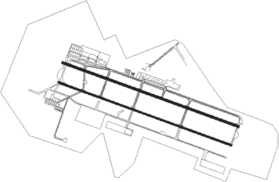
Taxiway locations
Parking locations
|
Nearby beacons
| code | identifier | dist | bearing | frequency |
|---|---|---|---|---|
| SYZ | SHIRAZ VOR/DME | 0 | 123° | 117.80 |
| SR | SHIRAZ NDB | 0.8 | 136° | 205 |
Departure and arrival routes
| Transition altitude | 13000ft |
| SID end points | distance | outbound heading | |
|---|---|---|---|
| RW11 (ALL) | |||
| KINO1B, KINO1F | 70mi | 35° | |
| NALB1B, NALB1F | 70mi | 80° | |
| TAGT1B, TAGT1F | 70mi | 131° | |
| KASO1B, KASO1F | 70mi | 146° | |
| KUPT1F, KUPT1B | 70mi | 164° | |
| KATA1F, KATA1B | 70mi | 194° | |
| DEPS1D, DEPS1F, DEPS1H, DEPS1B | 70mi | 217° | |
| KATU1B, KATU1D, KATU1F, KATU1H | 70mi | 243° | |
| KUGV1B, KUGV1D, KUGV1H, KUGV1F | 70mi | 252° | |
| IVER1B, IVER1D | 70mi | 263° | |
| KAVI1F, KAVI1B | 70mi | 281° | |
| KISE1F, KISE1B | 70mi | 307° | |
| ASNI1F, ASNI1B | 70mi | 339° | |
| KAVO1B, KAVO1F | 70mi | 347° | |
| RW29 (ALL) | |||
| KINO1E, KINO1A | 70mi | 35° | |
| NALB1E, NALB1A | 70mi | 80° | |
| TAGT1A, TAGT1E | 70mi | 131° | |
| KASO1A, KASO1E | 70mi | 146° | |
| KUPT1A, KUPT1E | 70mi | 164° | |
| KATA1A, KATA1E | 70mi | 194° | |
| DEPS1G, DEPS1E, DEPS1C, DEPS1A | 70mi | 217° | |
| KATU1G, KATU1C, KATU1A, KATU1E | 70mi | 243° | |
| KUGV1G, KUGV1C, KUGV1A, KUGV1E | 70mi | 252° | |
| IVER1C, IVER1A | 70mi | 263° | |
| KAVI1E, KAVI1A | 70mi | 281° | |
| KISE1A, KISE1E | 70mi | 307° | |
| ASNI1E, ASNI1A | 70mi | 339° | |
| KAVO1A, KAVO1C, KAVO1E | 70mi | 347° | |
| STAR starting points | distance | inbound heading | |
|---|---|---|---|
| RW29 (ALL) | |||
| KATA1R, KATA1S | 70.2 | 14° | |
| LAGS1P, LAGS1R, LAGS1S | 60.6 | 14° | |
| DEPS1S, DEPS1R | 70.1 | 37° | |
| DASD1S, DASD1R, DASD1P | 46.2 | 38° | |
| KATU1T, KATU1S, KATU1R | 69.9 | 63° | |
| KUGV1R, KUGV1S, KUGV1T, KUGV1X | 69.9 | 72° | |
| IVER1X, IVER1T, IVER1S | 70.0 | 83° | |
| KAVI1X, KAVI1T, KAVI1S, KAVI1R | 69.8 | 101° | |
| KISE2X, KISE1S, KISE1R | 69.9 | 127° | |
| ASNI1X, ASNI1S, ASNI1R, ASNI1P | 70.1 | 159° | |
| KAVO1P, KAVO1R, KAVO1S | 70.2 | 167° | |
| KINO1P, KINO1S, KINO1R | 70.0 | 215° | |
| NALB1P, NALB1S | 69.9 | 260° | |
| VAVA1S, VAVA1R | 70.0 | 281° | |
| TAGT1S, TAGT1T, TAGT1R | 70.0 | 311° | |
| KASO1R, KASO1S | 70.1 | 326° | |
| KUPT1S, KUPT1R | 70.2 | 344° | |
Holding patterns
| STAR name | hold at | type | turn | heading* | altitude | leg | speed limit |
|---|---|---|---|---|---|---|---|
| ASNI1P | SADIA | VHF | right | 75 (255)° | > 13000ft | 1.0min timed | 230 |
| ASNI1R | HAFEZ | VHF | left | 148 (328)° | > 13000ft | 1.0min timed | 230 |
| ASNI1X | D287T | VHF | right | 287 (107)° | > 12500ft | 1.0min timed | 230 |
| DASD1P | SADIA | VHF | right | 75 (255)° | > 13000ft | 1.0min timed | 230 |
| DASD1R | HAFEZ | VHF | left | 148 (328)° | > 13000ft | 1.0min timed | 230 |
| DEPS1R | HAFEZ | VHF | left | 148 (328)° | > 13000ft | 1.0min timed | 230 |
| IVER1X | D287T | VHF | right | 287 (107)° | > 12500ft | 1.0min timed | 230 |
| KASO1R | HAFEZ | VHF | left | 148 (328)° | > 13000ft | 1.0min timed | 230 |
| KATA1R | HAFEZ | VHF | left | 148 (328)° | > 13000ft | 1.0min timed | 230 |
| KATU1R | HAFEZ | VHF | left | 148 (328)° | > 13000ft | 1.0min timed | 230 |
| KAVI1R | HAFEZ | VHF | left | 148 (328)° | > 13000ft | 1.0min timed | 230 |
| KAVI1X | D287T | VHF | right | 287 (107)° | > 12500ft | 1.0min timed | 230 |
| KAVO1P | SADIA | VHF | right | 75 (255)° | > 13000ft | 1.0min timed | 230 |
| KAVO1R | HAFEZ | VHF | left | 148 (328)° | > 13000ft | 1.0min timed | 230 |
| KINO1P | SADIA | VHF | right | 75 (255)° | > 13000ft | 1.0min timed | 230 |
| KINO1R | HAFEZ | VHF | left | 148 (328)° | > 13000ft | 1.0min timed | 230 |
| KISE1R | HAFEZ | VHF | left | 148 (328)° | > 13000ft | 1.0min timed | 230 |
| KISE2X | D287T | VHF | right | 287 (107)° | > 12500ft | 1.0min timed | 230 |
| KUGV1R | HAFEZ | VHF | left | 148 (328)° | > 13000ft | 1.0min timed | 230 |
| KUGV1X | D287T | VHF | right | 287 (107)° | > 12500ft | 1.0min timed | 230 |
| KUPT1R | HAFEZ | VHF | left | 148 (328)° | > 13000ft | 1.0min timed | 230 |
| LAGS1P | SADIA | VHF | right | 75 (255)° | > 13000ft | 1.0min timed | 230 |
| LAGS1R | HAFEZ | VHF | left | 148 (328)° | > 13000ft | 1.0min timed | 230 |
| NALB1P | SADIA | VHF | right | 75 (255)° | > 13000ft | 1.0min timed | 230 |
| TAGT1R | HAFEZ | VHF | left | 148 (328)° | > 13000ft | 1.0min timed | 230 |
| VAVA1R | HAFEZ | VHF | left | 148 (328)° | > 13000ft | 1.0min timed | 230 |
| *) magnetic outbound (inbound) holding course | |||||||
Disclaimer
The information on this website is not for real aviation. Use this data with the X-Plane flight simulator only! Data taken with kind consent from X-Plane 12 source code and data files. Content is subject to change without notice.