Ardabil
Airport details
| Country | Iran |
| State | Ardabil Province |
| Region | OI |
| Airspace | Tehran Ctr |
| Municipality | دهستان کلخوران |
| Elevation | 4312ft (1314m) |
| Timezone | GMT +3.5 |
| Coordinates | 38.32667, 48.42417 |
| Magnetic var | |
| Type | land |
| Available since | X-Plane v10.32 |
| ICAO code | OITL |
| IATA code | ADU |
| FAA code | n/a |
Communication
| Ardabil ATIS | 126.650 |
| Ardabil INFO | 118.150 |
| Ardabil INFO | 121.900 |
Approach frequencies
| ILS-cat-I | RW33 | 109.9 | 18.00mi |
| ILS-cat-I | RW15 | 110.3 | 18.00mi |
| 3.5° GS | RW33 | 109.9 | 18.00mi |
| 3.2° GS | RW15 | 110.3 | 18.00mi |
Nearby Points of Interest:
Aghazadeh House (Ardabil)
-Shater Tower
-Hirkan National Park
-Estil Lagoon
-Bar Bar Castle
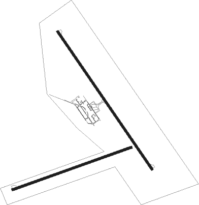
Runway info
Runway 07 / 25  | ||
| length | 2493m (8179ft) | |
| bearing | 78° / 258° | |
| width | 43m (141ft) | |
| surface | asphalt | |
| blast zone | 103m (338ft) / 255m (837ft) | |
| Runway 15 / 33 | ||
| length | 3302m (10833ft) | |
| bearing | 144° / 324° | |
| width | 45m (148ft) | |
| surface | asphalt | |
| blast zone | 255m (837ft) / 255m (837ft) | |
Nearby beacons
| code | identifier | dist | bearing | frequency |
|---|---|---|---|---|
| ARB | ARDABIL NDB | 0.4 | 294° | 355 |
| ARB | ARDABIL VOR/DME | 0.8 | 136° | 115.70 |
| L | LENKORAN NDB | 30.9 | 44° | 740 |
Departure and arrival routes
| Transition altitude | 9000ft |
| SID end points | distance | outbound heading | |
|---|---|---|---|
| RW07 | |||
| GIVT1P | 26mi | 130° | |
| EGVO1H, EGVO1P | 25mi | 265° | |
| ITUP1P, ITUP1H | 24mi | 303° | |
| RW15 | |||
| GIVT1B, GIVT1C, GIVT1L, GIVT1M | 26mi | 130° | |
| EGVO1L | 25mi | 265° | |
| ITUP1L | 24mi | 303° | |
| RW25 | |||
| GIVT1N | 26mi | 130° | |
| EGVO1N, EGVO1G | 25mi | 265° | |
| ITUP1G, ITUP1N | 24mi | 303° | |
| RW33 | |||
| GIVT1A, GIVT1J | 26mi | 130° | |
| EGVO1J | 25mi | 265° | |
| ITUP1J | 24mi | 303° | |
| STAR starting points | distance | inbound heading | |
|---|---|---|---|
| ALL | |||
| EGVO1J, EGVO1K, EGVO1M | 24.5 | 85° | |
| ITUP1M, ITUP1K, ITUP1J | 23.5 | 123° | |
| GIVT1M, GIVT1J, GIVT1F | 25.6 | 310° | |
| RW07 | |||
| GIVT1N | 25.6 | 310° | |
| RW15 | |||
| GIVT1L | 25.6 | 310° | |
| RW33 | |||
| GIVT1K, GIVT1H | 25.6 | 310° | |
Holding patterns
| STAR name | hold at | type | turn | heading* | altitude | leg | speed limit |
|---|---|---|---|---|---|---|---|
| EGVO1K | D205K | VHF | left | 205 (25)° | 8500ft - 18000ft | 1.0min timed | 185 |
| EGVO1M | D215L | VHF | right | 215 (35)° | 9000ft - 18000ft | 1.0min timed | 185 |
| GIVT1H | D205K | VHF | left | 205 (25)° | 8500ft - 18000ft | 1.0min timed | 185 |
| GIVT1K | D205K | VHF | left | 205 (25)° | 8500ft - 18000ft | 1.0min timed | 185 |
| GIVT1L | D215L | VHF | right | 215 (35)° | 9000ft - 18000ft | 1.0min timed | 185 |
| GIVT1M | D215L | VHF | right | 215 (35)° | 9000ft - 18000ft | 1.0min timed | 185 |
| ITUP1K | D205K | VHF | left | 205 (25)° | 8500ft - 18000ft | 1.0min timed | 185 |
| ITUP1M | D215L | VHF | right | 215 (35)° | 9000ft - 18000ft | 1.0min timed | 185 |
| *) magnetic outbound (inbound) holding course | |||||||
Disclaimer
The information on this website is not for real aviation. Use this data with the X-Plane flight simulator only! Data taken with kind consent from X-Plane 12 source code and data files. Content is subject to change without notice.