Parker - Avi Suquilla
Airport details
| Country | United States of America |
| State | Arizona |
| Region | K2 |
| Airspace | Los Angeles Ctr |
| Municipality | La Paz County |
| Elevation | 452ft (138m) |
| Timezone | GMT -7 |
| Coordinates | 34.14983, -114.26783 |
| Magnetic var | |
| Type | land |
| Available since | X-Plane v10.40 |
| ICAO code | P20 |
| IATA code | n/a |
| FAA code | n/a |
Communication
| AVI SUQUILLA CTAF/UNICOM | 122.725 |
Nearby Points of Interest:
Turtle Mountains
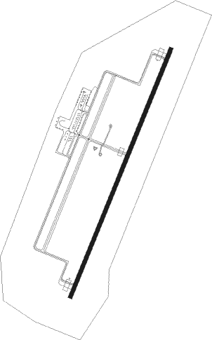
Runway info
| Runway 1 / 19 | ||
| length | 2003m (6572ft) | |
| bearing | 31° / 211° | |
| width | 30m (98ft) | |
| surface | asphalt | |
| displ threshold | 48m (157ft) / 48m (157ft) | |
Nearby beacons
| code | identifier | dist | bearing | frequency |
|---|---|---|---|---|
| PKE | PARKER VORTAC | 20.7 | 263° | 117.90 |
| EED | NEEDLES VORTAC | 38.3 | 341° | 115.20 |
| BLH | BLYTHE VORTAC | 41.3 | 222° | 117.40 |
| GFS | GOFFS VORTAC | 74 | 317° | 114.40 |
Instrument approach procedures
| runway | airway (heading) | route (dist, bearing) |
|---|---|---|
| RW01 | PKE (83°) | PKE COAPT (7mi, 112°) 5500ft BAKSE (10mi, 112°) 3700ft |
| RW01 | ROGBE (58°) | ROGBE DINBE (13mi, 73°) 5000ft BAKSE (6mi, 73°) 3700ft |
| RNAV | BAKSE 3700ft APHIS (5mi, 31°) 2400ft P20 (7mi, 31°) 494ft (6599mi, 107°) 1100ft PKE (6620mi, 287°) 5500ft PKE (turn) |
Disclaimer
The information on this website is not for real aviation. Use this data with the X-Plane flight simulator only! Data taken with kind consent from X-Plane 12 source code and data files. Content is subject to change without notice.