Bally - Area 52
Airport details
| Country | United States of America |
| State | Pennsylvania |
| Region | K6 |
| Airspace | New York Ctr |
| Municipality | Hereford Township |
| Elevation | 660ft (201m) |
| Timezone | GMT -5 |
| Coordinates | 40.43200, -75.62600 |
| Magnetic var | |
| Type | land |
| Available since | X-Plane v11.51r1 |
| ICAO code | PA35 |
| IATA code | n/a |
| FAA code | PA35 |
Communication
Nearby Points of Interest:
Hunter's Mill Complex
-Dale Furnace and Forge Historic District
-Borneman Mill
-John Gehman Farm
-Philip Christman House
-Mary Ann Furnace Historic District
-Long-Hawerter Mill
-Yoder Mill
-Mill at Lobachsville
-Nicholas Johnson Mill
-Sally Ann Furnace Complex
-Valentine Weaver House
-Keim Homestead
-Hartman Cider Press
-Bahr Mill Complex
-Ironstone Bridge
-Red Hill Historic District
-Boyer-Mertz Farm
-Oley Township
-Hottenstein Mansion
-Henry Fisher House
-Siegfried's Dale Farm
-Long Meadow Farm
-Kutztown 1892 Public School Building
-Andreas Rieth Homestead
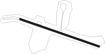
Runway info
| Runway 13 / 31 | ||
| length | 596m (1955ft) | |
| bearing | 109° / 289° | |
| width | 15m (50ft) | |
| surface | asphalt | |
| displ threshold | 84m (276ft) / 175m (574ft) | |
Nearby beacons
| code | identifier | dist | bearing | frequency |
|---|---|---|---|---|
| ETX | EAST TEXAS VOR/DME | 9.3 | 339° | 110.20 |
| PTW | POTTSTOWN VORTAC | 12.9 | 163° | 116.50 |
| FJC | ALLENTOWN VORTAC | 19.3 | 30° | 117.50 |
| ING | AMBLER NDB | 24.1 | 132° | 275 |
| MXE | MODENA VORTAC | 30.9 | 185° | 113.20 |
| ARD | YARDLEY VOR/DME | 34.5 | 104° | 108.20 |
| LRP | LANCASTER VOR/DME | 35.7 | 245° | 117.30 |
| SBJ | SOLBERG VOR/DME | 41.3 | 80° | 112.90 |
| BZJ | BELLGROVE (INDIANTOWN GAP) NDB | 42.3 | 270° | 328 |
| BWZ | BROADWAY (SCHOOLEY'S MT) VOR/DME | 42.7 | 66° | 114.20 |
| RAV | RAVINE VORTAC | 45 | 277° | 114.60 |
| DQO | DUPONT (WILMINGTON) VORTAC | 45.2 | 179° | 114 |
| STW | STILLWATER VOR/DME | 48.3 | 53° | 109.60 |
| OOD | WOODSTOWN VORTAC | 50 | 158° | 112.80 |
| LVZ | WILKES-BARRE VORTAC | 50.5 | 356° | 111.60 |
| IL | HADIN (WILMINGTON) NDB | 51 | 179° | 248 |
| VCN | CEDAR LAKE (MILLVILLE) VOR/DME | 61.6 | 144° | 115.20 |
Disclaimer
The information on this website is not for real aviation. Use this data with the X-Plane flight simulator only! Data taken with kind consent from X-Plane 12 source code and data files. Content is subject to change without notice.