Adak Island - Adak
Airport details
| Country | United States of America |
| State | Alaska |
| Region | PA |
| Municipality | Adak |
| Elevation | 18ft (5m) |
| Timezone | GMT -10 |
| Coordinates | 51.87803, -176.64592 |
| Magnetic var | |
| Type | land |
| Available since | X-Plane v10.30 |
| ICAO code | PADK |
| IATA code | ADK |
| FAA code | ADK |
Communication
| Adak AWOS 3 | 134.500 |
| Adak CTAF | 122.900 |
| Adak Anchorage Center | 126.400 |
Approach frequencies
| ILS-cat-I | RW23 | 108.9 | 18.00mi |
| 3.5° GS | RW23 | 108.9 | 18.00mi |
Runway info
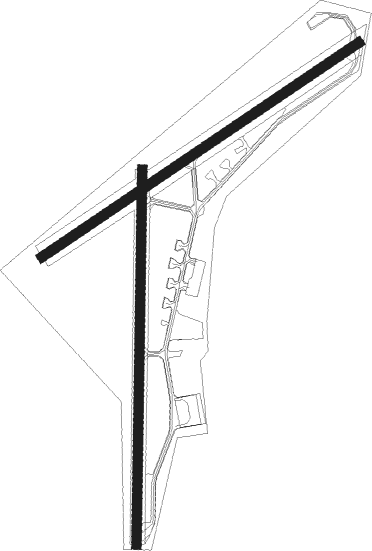
Runway 5 / 23  | ||
| length | 2363m (7753ft) | |
| bearing | 71° / 251° | |
| width | 61m (200ft) | |
| surface | asphalt | |
| displ threshold | 180m (591ft) / 0m (0ft) | |
| blast zone | 0m (0ft) / 3m (10ft) | |
| Runway 18 / 36 | ||
| length | 2318m (7605ft) | |
| bearing | 189° / 9° | |
| width | 61m (200ft) | |
| surface | asphalt | |
| displ threshold | 212m (696ft) / 0m (0ft) | |
Nearby beacons
| code | identifier | dist | bearing | frequency |
|---|---|---|---|---|
| ADK | MOUNT MOFFETT NDB | 1.1 | 258° | 530 |
| BER | ADAK (ADAK I) TACAN | 1.1 | 256° | 113 |
| NUD | ADAK TACAN | 1.1 | 257° | 113 |
Departure and arrival routes
| Transition altitude | 18000ft |
| Transition level | 18000ft |
| SID end points | distance | outbound heading | |
|---|---|---|---|
| RW05 | |||
| JALEX3 | 44mi | 76° | |
| RW23 | |||
| TTAUN4 | 44mi | 76° | |
Instrument approach procedures
| runway | airway (heading) | route (dist, bearing) |
|---|---|---|
| RW23 | DEJJE (97°) | DEJJE BAERE (44mi, 77°) 6600ft YIQTO (14mi, 231°) 3500ft |
| RW23 | SIYNY (256°) | SIYNY BAERE (29mi, 270°) 6600ft YIQTO (14mi, 231°) 3500ft |
| RNAV | YIQTO 3500ft GATIF (5mi, 231°) 2500ft WAURI (5mi, 251°) 891ft (7688mi, 106°) 894ft XERIC (7697mi, 286°) 6600ft DEJJE (17mi, 297°) DEJJE (turn) |
Disclaimer
The information on this website is not for real aviation. Use this data with the X-Plane flight simulator only! Data taken with kind consent from X-Plane 12 source code and data files. Content is subject to change without notice.