Eagle
Airport details
| Country | United States of America |
| State | Alaska |
| Region | PA |
| Municipality | Unorganized Borough |
| Elevation | 907ft (276m) |
| Timezone | GMT -9 |
| Coordinates | 64.77808, -141.14961 |
| Magnetic var | |
| Type | land |
| Available since | X-Plane v10.40 |
| ICAO code | PAEG |
| IATA code | EAA |
| FAA code | EAA |
Communication
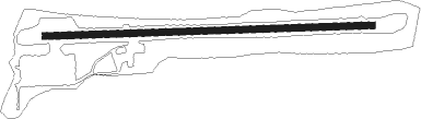
Runway info
| Runway 07 / 25 | ||
| length | 1094m (3589ft) | |
| bearing | 91° / 271° | |
| width | 23m (75ft) | |
| surface | gravel | |
Nearby beacons
| code | identifier | dist | bearing | frequency |
|---|---|---|---|---|
| EAA | DME | 0.2 | 92° | 114.25 |
Instrument approach procedures
| runway | airway (heading) | route (dist, bearing) |
|---|---|---|
| RWNVA | BAMVE (103°) | BAMVE 6600ft |
| RWNVA | DEYEP (96°) | DEYEP ZESIK (76mi, 91°) 7800ft BAMVE (21mi, 108°) 6600ft |
| RNAV | BAMVE 6600ft WERVU (10mi, 108°) 4600ft AYACO (3mi, 98°) 3920ft IPERE (6mi, 98°) 3020ft (6569mi, 115°) 3020ft BAMVE (6573mi, 295°) 6600ft BAMVE (turn) 6600ft |
Disclaimer
The information on this website is not for real aviation. Use this data with the X-Plane flight simulator only! Data taken with kind consent from X-Plane 12 source code and data files. Content is subject to change without notice.