Seward
Airport details
| Country | United States of America |
| State | Alaska |
| Region | PA |
| Municipality | Seward |
| Elevation | 20ft (6m) |
| Timezone | GMT -9 |
| Coordinates | 60.13008, -149.41684 |
| Magnetic var | |
| Type | land |
| Available since | X-Plane v10.40 |
| ICAO code | PAWD |
| IATA code | SWD |
| FAA code | SWD |
Communication
| Seward ASOS | 135.200 |
| Seward CTAF | 122.900 |
Nearby Points of Interest:
Jesse Lee Home for Children
-Ballaine House
-Government Cable Office
-Swetman House
-Brown & Hawkins Store
-Lowell Creek Diversion Tunnel
-Hoben Park
-Alaska Nellie's Homestead
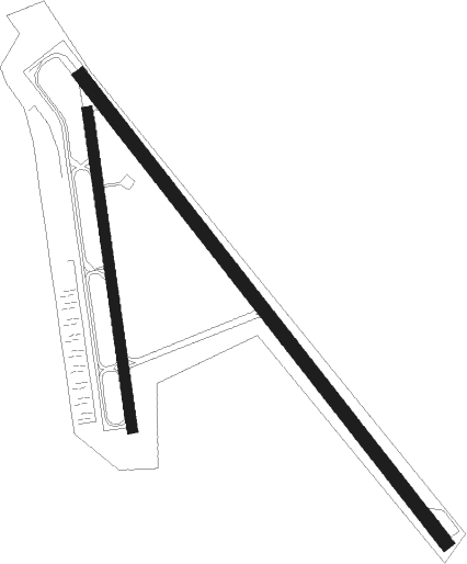
Runway info
Runway 13 / 31  | ||
| length | 1290m (4232ft) | |
| bearing | 127° / 307° | |
| width | 30m (100ft) | |
| surface | asphalt | |
| Runway 16 / 34 | ||
| length | 696m (2283ft) | |
| bearing | 173° / 353° | |
| width | 23m (75ft) | |
| surface | asphalt | |
Departure and arrival routes
| Transition altitude | 18000ft |
| Transition level | 18000ft |
| SID end points | distance | outbound heading | |
|---|---|---|---|
| RW13 | |||
| SEWAR1 | 11mi | 299° | |
Instrument approach procedures
| runway | airway (heading) | route (dist, bearing) |
|---|---|---|
| RWNVA | BROIL (138°) | BROIL SAKHI (11mi, 108°) 6700ft COPVI (4mi, 160°) 6200ft |
| RNAV | COPVI 6200ft UTANY (2mi, 160°) 5900ft BRINT (4mi, 190°) 4300ft ECAXE (4mi, 190°) 2660ft TUJVE (13mi, 162°) HEXEG (8mi, 259°) WIXIR (17mi, 321°) SEWAR (9mi, 42°) 9500ft SEWAR (turn) |
Disclaimer
The information on this website is not for real aviation. Use this data with the X-Plane flight simulator only! Data taken with kind consent from X-Plane 12 source code and data files. Content is subject to change without notice.