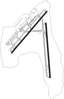
Lihue
Airport details
| Country | United States of America |
| State | Hawaii |
| Region | PH |
| Airspace | Honolulu Control Facility Ctr |
| Municipality | Kauaʻi County |
| Elevation | 149ft (45m) |
| Timezone | GMT -10 |
| Coordinates | 21.98390, -159.34496 |
| Magnetic var | |
| Type | land |
| Available since | X-Plane v10.40 |
| ICAO code | PHLI |
| IATA code | LIH |
| FAA code | LIH |
Communication
| Lihue ATIS | 127.200 |
| Lihue CTAF | 118.900 |
| Lihue Ground Control | 121.900 |
| Lihue Tower | 118.900 |
| Lihue Tower | 128.400 |
| Lihue Departure | 133.000 |
Approach frequencies
| ILS-cat-I | RW35 | 110.9 | 18.00mi |
| 3° GS | RW35 | 110.9 | 18.00mi |
Nearby Points of Interest:
Lihue Civic Center Historic District
-United States Post Office–Lihue
-Grove Farm
-Menehune Fishpond
-Opaekaa Road Bridge
-Pu'u'opae Bridge
-Seto Building
-Kilauea School
-Hanapepe Town Lot No. 18
-Kong Lung Store
-Haraguchi Rice Mill
-Waioli Mission District
-Albert Spencer Wilcox Beach House
-Hawaii Route 560
-Kikiaola
-Cook Landing Site
-Yamase Building
-Gulick-Rowell House
-Camp Sloggett
Nearby beacons
| code | identifier | dist | bearing | frequency |
|---|---|---|---|---|
| LIH | LIHUE VORTAC | 1.1 | 160° | 113.50 |
| SOK | SOUTH KAUAI VORTAC | 11.4 | 246° | 115.40 |
| NBS | BARKING SANDS (KAUAI I.) TACAN | 24.7 | 277° | 112.60 |
Departure and arrival routes
| Transition altitude | 18000ft |
| Transition level | 18000ft |
| SID end points | distance | outbound heading | |
|---|---|---|---|
| RW03 | |||
| LIHUE5 | 176mi | 108° | |
| RW17 | |||
| RICHE2 | 176mi | 108° | |
| RW21 | |||
| RICHE2 | 176mi | 108° | |
| RW35 | |||
| LIHUE5 | 176mi | 108° | |
Instrument approach procedures
| runway | airway (heading) | route (dist, bearing) |
|---|---|---|
| RW17 | NAPUA (338°) | NAPUA COBIK (22mi, 6°) 3000ft MEGUE (4mi, 285°) 2400ft |
| RNAV | MEGUE 2400ft WIDLO (5mi, 212°) 1600ft CUBIG (4mi, 196°) 306ft (9019mi, 98°) 553ft NAGAI (9025mi, 278°) 3000ft NAGAI (turn) | |
| RW21-Y | NAPUA (338°) | NAPUA IVATE (20mi, 18°) 4000ft COBIK (5mi, 313°) 2700ft |
| RNAV | COBIK 2700ft OPORE (5mi, 227°) 1900ft JABDI (4mi, 227°) 459ft NAGAI (14mi, 164°) 3000ft NAGAI (turn) | |
| RW21-Z | GRAIL (314°) | GRAIL ZIKAB (15mi, 338°) 4000ft MAHAO (17mi, 338°) 4000ft ANUYA (10mi, 313°) 2800ft |
| RNAV | ANUYA 2800ft OPORE (7mi, 227°) 1900ft PHLI (6mi, 230°) 135ft (9020mi, 98°) 552ft ZIKAB (9014mi, 278°) 3000ft ZIKAB (turn) | |
| RW35-Y | NAPUA (338°) | NAPUA MORKE (6mi, 300°) 3000ft |
| RNAV | MORKE 3000ft AKULE (5mi, 360°) 1900ft PHLI (7mi, 355°) 147ft KREEN (12mi, 87°) 3000ft KREEN (turn) | |
| RW35-Z | NAPUA (338°) | NAPUA MORKE (6mi, 300°) 3000ft |
| RNAV | MORKE 3000ft AKULE (5mi, 360°) 1900ft PHLI (7mi, 355°) 147ft (9020mi, 98°) 553ft KREEN (9011mi, 278°) 3000ft KREEN (turn) |
Disclaimer
The information on this website is not for real aviation. Use this data with the X-Plane flight simulator only! Data taken with kind consent from X-Plane 12 source code and data files. Content is subject to change without notice.

