Kaunakakai - Molokai
Airport details
| Country | United States of America |
| State | Hawaii |
| Region | PH |
| Airspace | Honolulu Control Facility Ctr |
| Municipality | Kualapuu |
| Elevation | 454ft (138m) |
| Timezone | GMT -10 |
| Coordinates | 21.15289, -157.09625 |
| Magnetic var | |
| Type | land |
| Available since | X-Plane v10.40 |
| ICAO code | PHMK |
| IATA code | MKK |
| FAA code | MKK |
Communication
| Molokai ATIS | 128.200 |
| Molokai CTAF | 125.700 |
| Molokai Ground Control | 121.900 |
| Molokai Tower | 125.700 |
| Molokai Departure | 125.700 |
Nearby Points of Interest:
Lanai City
-Pu'upehe Platform
-Wo Hing Society Hall
-Mokuʻula
-Lahainaluna High School
-Waihee Church
-Tantalus-Round Top Road
-Chee Kung Tong Society Building
-Wailuku Civic Center Historic District
-Wailuku School
-Kaahumanu Church
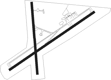
Runway info
Runway 5 / 23  | ||
| length | 1373m (4505ft) | |
| bearing | 62° / 242° | |
| width | 30m (100ft) | |
| surface | asphalt | |
| displ threshold | 0m (0ft) / 181m (594ft) | |
| Runway 17 / 35 | ||
| length | 955m (3133ft) | |
| bearing | 180° / 360° | |
| width | 30m (100ft) | |
| surface | asphalt | |
| displ threshold | 130m (427ft) / 0m (0ft) | |
Nearby beacons
| code | identifier | dist | bearing | frequency |
|---|---|---|---|---|
| MKK | MOLOKAI (KAUNAKAKAI) VORTAC | 4 | 258° | 116.10 |
| LLD | LANAI NDB | 23.8 | 162° | 353 |
| LNY | LANAI (LANAI CITY) VORTAC | 24.3 | 162° | 117.70 |
| CKH | KOKO HEAD VORTAC | 34.6 | 280° | 113.90 |
| VYI | VALLEY ISLAND (KAHULUI) NDB | 40.1 | 113° | 327 |
| OGG | MAUI (KAHULUI) VORTAC | 40.6 | 110° | 115.10 |
| NGF | KANEOHE BAY (MOKAPU) NDB | 40.9 | 294° | 265 |
| NGF | KANEOHE BAY (MOKAPU) TACAN | 41.2 | 295° | 114.60 |
| HNL | HONOLULU VORTAC | 47.6 | 281° | 114.80 |
| HN | EWABE (HONOLULU) NDB | 54.3 | 280° | 242 |
Departure and arrival routes
| Transition altitude | 18000ft |
| Transition level | 18000ft |
| SID end points | distance | outbound heading | |
|---|---|---|---|
| RW05 | |||
| BLUSH2 | 26mi | 67° | |
| MAULA1 | 14mi | 263° | |
| RW17 | |||
| KALAE1 | 14mi | 263° | |
| RW23 | |||
| KALAE1 | 14mi | 263° | |
Instrument approach procedures
| runway | airway (heading) | route (dist, bearing) |
|---|---|---|
| RWNVB | GAKCU (170°) | GAKCU FEUDS (14mi, 180°) 3600ft ATOSE (4mi, 180°) 2500ft ATOSE (turn) 2500ft |
| RWNVB | LNY (342°) | LNY PETTN (14mi, 350°) 4000ft ATOSE (7mi, 281°) 2500ft |
| RWNVB | PALAY (84°) | PALAY CHARS (19mi, 101°) 4000ft ATOSE (7mi, 101°) 2500ft |
| RNAV | ATOSE 2500ft MIMLE (3mi, 13°) 2000ft JOPKI (4mi, 13°) 485ft (8962mi, 98°) 1200ft GAKCU (8956mi, 278°) 4000ft GAKCU (turn) 4000ft |
Disclaimer
The information on this website is not for real aviation. Use this data with the X-Plane flight simulator only! Data taken with kind consent from X-Plane 12 source code and data files. Content is subject to change without notice.