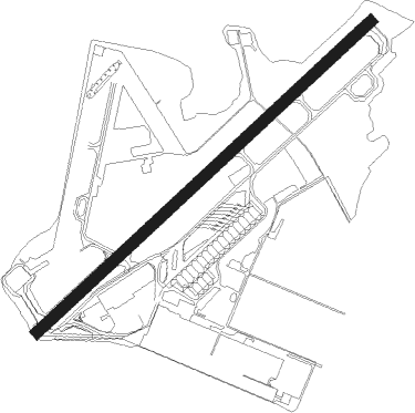
Kaneohe - Kaneohe Bay Mcaf
Airport details
| Country | United States of America |
| State | Hawaii |
| Region | PH |
| Airspace | Honolulu Control Facility Ctr |
| Municipality | Honolulu County |
| Elevation | 21ft (6m) |
| Timezone | GMT -10 |
| Coordinates | 21.45236, -157.77380 |
| Magnetic var | |
| Type | land |
| Available since | X-Plane v11.50 |
| ICAO code | PHNG |
| IATA code | NGF |
| FAA code | NGF |
Communication
| Kaneohe Bay MCAF CTAF | 120.700 |
| Kaneohe Bay MCAF Tower | 120.700 |
| Kaneohe Bay MCAF Approach/Departure | 125.000 |
Nearby Points of Interest:
Kawainui and Hamakua Marsh Complex
-Boettcher Estate
-Kahaluu Fish Pond
-Kahaluu Taro Lo'i
-Kaneohe Ranch Building
-Molii Fishpond
-Clarence H. Cooke House
-Edgar and Lucy Henriques House
-Koʻolau Range
-James L. Coke House
-Lihiwai
-Thomas Alexander Burningham House
-Georges de S. Canavarro House
-H. Alexander Walker Residence
-Salvation Army Waiʻoli Tea Room
-Jessie Eyman–Wilma Judson House
-Dr. Archibald Neil Sinclair House
-Tantalus-Round Top Road
-Grace Cooke House
-Palm Circle
-Charles Montague Cooke, Jr., House and Kūkaʻōʻō Heiau
-Alfred Hocking House
-R.N. Linn House
-George D. Oakley House
-John Guild House
Nearby beacons
| code | identifier | dist | bearing | frequency |
|---|---|---|---|---|
| NGF | KANEOHE BAY (MOKAPU) TACAN | 0.9 | 77° | 114.60 |
| NGF | KANEOHE BAY (MOKAPU) NDB | 1.1 | 92° | 265 |
| CKH | KOKO HEAD VORTAC | 11.9 | 159° | 113.90 |
| HNL | HONOLULU VORTAC | 12.3 | 227° | 114.80 |
| HN | EWABE (HONOLULU) NDB | 17.1 | 245° | 242 |
| MKK | MOLOKAI (KAUNAKAKAI) VORTAC | 38.8 | 117° | 116.10 |
| LLD | LANAI NDB | 60.6 | 130° | 353 |
| LNY | LANAI (LANAI CITY) VORTAC | 61.1 | 131° | 117.70 |
Departure and arrival routes
| Transition altitude | 18000ft |
| Transition level | 18000ft |
| SID end points | distance | outbound heading | |
|---|---|---|---|
| RW04 | |||
| HELUX5 | 39mi | 117° | |
| MUGGE9 | 12mi | 227° | |
| KANEO5 | 102mi | 284° | |
| RW22 | |||
| HELUX5 | 39mi | 117° | |
| MUGGE9 | 12mi | 227° | |
| KANEO5 | 102mi | 284° | |
Instrument approach procedures
| runway | airway (heading) | route (dist, bearing) |
|---|---|---|
| RW22-Y | CLYYD (230°) | CLYYD 3000ft |
| RW22-Y | MKK (297°) | MKK 3000ft BRYDG (25mi, 320°) 3000ft CLYYD (12mi, 309°) 3000ft |
| RW22-Y | ORIUN (183°) | ORIUN 3000ft CLYYD (12mi, 131°) 3000ft |
| RNAV | CLYYD 3000ft GOSTT (7mi, 225°) 1600ft WARIB (4mi, 233°) 386ft (8976mi, 98°) 900ft ORIUN (8966mi, 278°) 4200ft ORIUN (turn) 6000ft | |
| RW22-Z | CLYYD (230°) | CLYYD 3000ft |
| RW22-Z | MKK (297°) | MKK 3000ft BRYDG (25mi, 320°) 3000ft CLYYD (12mi, 309°) 3000ft |
| RW22-Z | ORIUN (183°) | ORIUN 3000ft CLYYD (12mi, 131°) 3000ft |
| RNAV | CLYYD 3000ft GOSTT (7mi, 225°) 1600ft WARIB (4mi, 233°) 386ft (8976mi, 98°) 423ft ORIUN (8966mi, 278°) 4100ft ORIUN (turn) 6000ft |
Disclaimer
The information on this website is not for real aviation. Use this data with the X-Plane flight simulator only! Data taken with kind consent from X-Plane 12 source code and data files. Content is subject to change without notice.