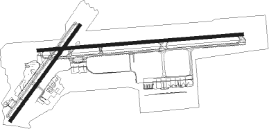
Hilo - Hilo Intl
Airport details
| Country | United States of America |
| State | Hawaii |
| Region | PH |
| Airspace | Honolulu Control Facility Ctr |
| Municipality | Hilo CDP |
| Elevation | 38ft (12m) |
| Timezone | GMT -10 |
| Coordinates | 19.72026, -155.04846 |
| Magnetic var | |
| Type | land |
| Available since | X-Plane v10.40 |
| ICAO code | PHTO |
| IATA code | ITO |
| FAA code | ITO |
Communication
| Hilo Intl ATIS | 126.400 |
| Hilo Intl CTAF | 118.100 |
| Hilo Intl Ground Control | 121.900 |
| Hilo Intl Tower | 118.100 |
| Hilo Intl Approach/Departure | 119.700 |
| Hilo Intl Approach/Departure | 126.600 |
Approach frequencies
| ILS-cat-I | RW26 | 110.7 | 18.00mi |
| 2.6° GS | RW26 | 110.7 | 18.00mi |
Nearby Points of Interest:
S. Hata Building
-Volcano Block Building
-Hilo Masonic Lodge Hall-Bishop Trust Building
-Federal Building, United States Post Office and Courthouse
-A.J. Williamson House
-W. H. Shipman House
-Crater Rim Trail
-Kilauea Caldera
-Ainahou Ranch
-Puna-Ka'u Historic District
-1790 Footprints
-Hilina Pali Shelter
-ʻĀinapō Trail
-Wilkes Campsite
Nearby beacons
| code | identifier | dist | bearing | frequency |
|---|---|---|---|---|
| ITO | HILO VORTAC | 2.1 | 88° | 116.90 |
| POA | PAHOA NDB | 11.5 | 157° | 332 |
| BSF | BRADSHAW (POHAKULOA) NDB | 30.9 | 275° | 339 |
| MUE | KAMUELA VOR/DME | 38.8 | 294° | 113.30 |
| UPP | UPOLU POINT (HAWI) VORTAC | 53.3 | 301° | 112.30 |
| KOA | KONA (KAILUA/KONA) VORTAC | 56.3 | 270° | 112.10 |
Departure and arrival routes
| Transition altitude | 18000ft |
| Transition level | 18000ft |
| SID end points | distance | outbound heading | |
|---|---|---|---|
| RW03 | |||
| PPKEO1 | 53mi | 301° | |
| PARIS4 | 29mi | 339° | |
| RW08 | |||
| PPKEO1 | 53mi | 301° | |
| PARIS4 | 29mi | 339° | |
| RW21 | |||
| PPKEO1 | 53mi | 301° | |
| PARIS4 | 29mi | 339° | |
| RW26 | |||
| PPKEO1 | 53mi | 301° | |
| PARIS4 | 29mi | 339° | |
| STAR starting points | distance | inbound heading | |
|---|---|---|---|
| RW21 | |||
| LYCHI1 | 24.5 | 164° | |
| RW26 | |||
| LYCHI1 | 24.5 | 164° | |
Instrument approach procedures
| runway | airway (heading) | route (dist, bearing) |
|---|---|---|
| RW21 | ARBOR (162°) | ARBOR KENNZ (6mi, 81°) 4000ft FAMBU (10mi, 139°) 3300ft |
| RW21 | HAKRI (259°) | HAKRI CABIX (19mi, 272°) 4000ft FAMBU (5mi, 291°) 3300ft |
| RNAV | FAMBU 3300ft KOPSE (6mi, 222°) 1800ft PHTO (5mi, 219°) 75ft (8924mi, 97°) 500ft CABIX (8910mi, 277°) 4000ft CABIX (turn) 4000ft | |
| RW26 | ARBOR (162°) | ARBOR KENNZ (6mi, 81°) 4000ft CABIX (15mi, 129°) 4000ft CEKOB (7mi, 180°) 2700ft |
| RW26 | GEBNE (278°) | GEBNE FAMOP (14mi, 289°) 4000ft CEKOB (6mi, 270°) 2700ft |
| RW26 | HAKRI (259°) | HAKRI FAMOP (14mi, 246°) 4000ft CEKOB (6mi, 270°) 2700ft |
| RNAV | CEKOB 2700ft WAKIK (5mi, 270°) 1800ft PHTO (7mi, 270°) 93ft (8924mi, 97°) 500ft CABIX (8910mi, 277°) 4000ft CABIX (turn) 4000ft |
Disclaimer
The information on this website is not for real aviation. Use this data with the X-Plane flight simulator only! Data taken with kind consent from X-Plane 12 source code and data files. Content is subject to change without notice.

