Cubero
Airport details
| Country | United States of America |
| State | New Mexico |
| Region | |
| Airspace | Albuquerque Ctr |
| Municipality | Cibola County |
| Elevation | 6191ft (1887m) |
| Timezone | GMT -7 |
| Coordinates | 35.08754, -107.56310 |
| Magnetic var | |
| Type | land |
| Available since | X-Plane v10.40 |
| ICAO code | Q57 |
| IATA code | n/a |
| FAA code | NM74 |
Communication
Nearby Points of Interest:
Acoma Curio Shop
-Charley's Automotive Service
-Bowlin's Old Crater Trading Post
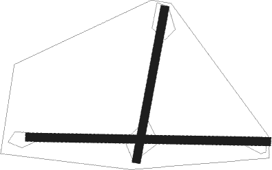
Runway info
Runway 08 / 26  | ||
| length | 855m (2805ft) | |
| bearing | 95° / 275° | |
| width | 30m (100ft) | |
| surface | dirt | |
| Runway 17 / 35 | ||
| length | 549m (1801ft) | |
| bearing | 198° / 18° | |
| width | 30m (100ft) | |
| surface | dirt | |
Nearby beacons
| code | identifier | dist | bearing | frequency |
|---|---|---|---|---|
| ABQ | ALBUQUERQUE VORTAC | 36.8 | 93° | 113.20 |
| AE | DUDLE (ALBUQUERQUE) NDB | 42.4 | 81° | 351 |
| BRG | DME | 44.5 | 121° | 114.75 |
| ONM | SOCORRO VORTAC | 58 | 135° | 116.80 |
Disclaimer
The information on this website is not for real aviation. Use this data with the X-Plane flight simulator only! Data taken with kind consent from X-Plane 12 source code and data files. Content is subject to change without notice.