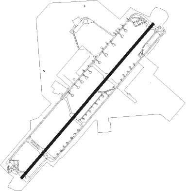
Hsinchu City - Hsinchu
Airport details
| Country | Taiwan |
| State | Hsinchu (city) |
| Region | RC |
| Airspace | Taipei Ctr |
| Municipality | Hsinchu |
| Elevation | 24ft (7m) |
| Timezone | GMT +8 |
| Coordinates | 24.81667, 120.93333 |
| Magnetic var | |
| Type | land |
| Available since | X-Plane v10.40 |
| ICAO code | RCPO |
| IATA code | HSZ |
| FAA code | n/a |
Communication
| Hsinchu Tower | 121.200 |
| Hsinchu Tower | 118.400 |
| Hsinchu TAIPEI Approach | 123.500 |
Approach frequencies
| ILS-cat-I | RW05 | 108.7 | 18.00mi |
| 3° GS | RW05 | 108.7 | 18.00mi |
Nearby Points of Interest:
Hsinchu Municipal Government Hall
-the Tomb of Zheng Yong-xi
-Hsinchu Jinshan Temple
-Tianmei Yonghe Temple
-Fangou Shrine
-Sanxia Zaishu Temple
-Sanxia Arch Bridge
-Wugu XiYun temple
-Dajia Wenchang Temple
-Li Family Abode
-Red Building of Taipei Municipal Jianguo High School
-Yen Chia-Kan's Residence
-Judicial Yuan Building
-National Taiwan University Hospital
-Ren'an Hospital
-Control Yuan
-Taiwan New Cultural Movement Memorial Hall
-Former Dadaocheng Substation
Nearby beacons
| code | identifier | dist | bearing | frequency |
|---|---|---|---|---|
| HSU | HSINCHU TACAN | 0.3 | 40° | 116.30 |
| RA | LUNGTANG NDB | 17.6 | 82° | 202 |
| HL | HOULONG NDB | 18.8 | 219° | 362 |
| HLG | HOULONG VOR/DME | 19 | 219° | 114 |
| TYN | TAOYUAN TACAN | 22.4 | 52° | 115.80 |
| WK | HSINSHIE NDB | 35.5 | 191° | 340 |
| SG | SONGSHAN (TAIPEI) NDB | 35.8 | 67° | 310 |
| CCK | CINGCYUANGANG TACAN | 37.4 | 210° | 111.30 |
| TSI | SONGSHAN (TAIPEI) VOR/DME | 37.5 | 68° | 113.50 |
| TC | CINGCYUANGANG (TAICHUNG) NDB | 37.9 | 209° | 210 |
| TCK | (TAICHUNG) DME | 37.9 | 209° | 108.40 |
| AP | ANBU NDB | 38.6 | 59° | 250 |
| APU | ANBU (TAIPEI) VOR/DME | 38.6 | 59° | 112.50 |
| LU | KEELUNG NDB | 51 | 70° | 357 |
| YU | HUALIEN NDB | 61.1 | 139° | 380 |
| HLN | HUALIEN VOR/DME | 61.5 | 138° | 114.10 |
| HW | HUALIEN NDB | 67.2 | 149° | 280 |
Disclaimer
The information on this website is not for real aviation. Use this data with the X-Plane flight simulator only! Data taken with kind consent from X-Plane 12 source code and data files. Content is subject to change without notice.