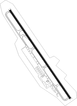
Kagoshima
Airport details
| Country | Japan |
| State | Kagoshima Prefecture |
| Region | RJ |
| Airspace | Fukuoka Ctr |
| Municipality | Kirishima |
| Elevation | 892ft (272m) |
| Timezone | GMT +9 |
| Coordinates | 31.79618, 130.72131 |
| Magnetic var | |
| Type | land |
| Available since | X-Plane v10.40 |
| ICAO code | RJFK |
| IATA code | KOJ |
| FAA code | n/a |
Communication
| Kagoshima ATIS | 127.050 |
| Kagoshima Clearance DEL | 121.800 |
| Kagoshima Ground Control | 121.700 |
| Kagoshima Tower | 126.200 |
| Kagoshima Tower | 118.200 |
| Kagoshima Approach | 119.400 |
| Kagoshima Approach | 126.000 |
| Kagoshima TCA | 120.000 |
| Kagoshima Approach | 120.800 |
| Kagoshima Departure | 119.400 |
Approach frequencies
| ILS-cat-I | RW34 | 111.7 | 18.00mi |
| 3° GS | RW34 | 111.7 | 18.00mi |
Nearby Points of Interest:
Shūseikan
-Sengan-en
Nearby beacons
| code | identifier | dist | bearing | frequency |
|---|---|---|---|---|
| KGE | KAJIKI (KAGOSHIMA) VOR/DME | 0.2 | 74° | 115.70 |
| HKC | KAGOSHIMA VORTAC | 9.2 | 234° | 113.30 |
| JAT | KANOYA TACAN | 26.6 | 166° | 113.80 |
| JA | KANOYA NDB | 27.2 | 164° | 238 |
| MZE | MIYAZAKI VOR/DME | 36.8 | 83° | 112.40 |
| NHT | NYUTABARU TACAN | 41 | 69° | 115 |
| ZZT | NYUTABARU TACAN | 41 | 69° | 135.90 |
| AKE | AMAKUSA VOR/DME | 49.9 | 321° | 113.45 |
Departure and arrival routes
| Transition altitude | 14000ft |
| Transition level | 14000ft |
| SID end points | distance | outbound heading | |
|---|---|---|---|
| RW16 | |||
| MIDAI3 | 35mi | 106° | |
| OSUMI5 | 48mi | 210° | |
| SOGIE3 | 32mi | 338° | |
| RW34 | |||
| MIDAI3 | 35mi | 106° | |
| OSUMI5 | 48mi | 210° | |
| SOGIE3 | 32mi | 338° | |
| STAR starting points | distance | inbound heading | |
|---|---|---|---|
| RW16 | |||
| YUKSA | 21.8 | 208° | |
| OGOJO | 37.7 | 258° | |
| RW34 | |||
| KINKOH | 27.8 | 0° | |
| SIMAZS | 15.2 | 43° | |
| SIMAZE | 37.7 | 258° | |
Instrument approach procedures
| runway | airway (heading) | route (dist, bearing) |
|---|---|---|
| RW16 | OGOJO (177°) | OGOJO 5000ft WAZZE (6mi, 244°) 3500ft |
| RW16 | OIDON (119°) | OIDON 4500ft WAZZE (6mi, 64°) 3500ft |
| RW16 | YUKSA (146°) | YUKSA 5000ft WAZZE (6mi, 146°) 3500ft |
| RNAV | WAZZE 3500ft 80THR (3mi, 146°) 3200ft YUSUI (3mi, 146°) 2707ft 34THR (2mi, 146°) 2038ft RJFK (5mi, 148°) 963ft (7428mi, 256°) 1400ft HKC (7424mi, 76°) 4500ft HKC (turn) 4500ft |
Holding patterns
| STAR name | hold at | type | turn | heading* | altitude | leg | speed limit |
|---|---|---|---|---|---|---|---|
| KINKOH | YOGAN | VHF | right | 157 (337)° | > 6000ft | DME 5.7mi | 230 |
| SIMAZE | CELES | VHF | left | 85 (265)° | 4100ft - 14000ft | 1.0min timed | 230 |
| SIMAZN | HKC | NDB | right | 290 (110)° | > 4500ft | 1.0min timed | ICAO rules |
| SIMAZS | ISKID | VHF | left | 207 (27)° | > 6000ft | DME 9.5mi | 240 |
| *) magnetic outbound (inbound) holding course | |||||||
Disclaimer
The information on this website is not for real aviation. Use this data with the X-Plane flight simulator only! Data taken with kind consent from X-Plane 12 source code and data files. Content is subject to change without notice.
