Niigata
Airport details
| Country | Japan |
| State | Niigata Prefecture |
| Region | RJ |
| Airspace | Fukuoka Ctr |
| Municipality | Niigata |
| Elevation | 27ft (8m) |
| Timezone | GMT +9 |
| Coordinates | 37.95583, 139.11166 |
| Magnetic var | |
| Type | land |
| Available since | X-Plane v10.40 |
| ICAO code | RJSN |
| IATA code | KIJ |
| FAA code | n/a |
Communication
| Niigata ATIS | 128.450 |
| Niigata Tower | 126.200 |
| Niigata Tower | 118.000 |
| Niigata Approach | 121.400 |
| Niigata Departure | 119.050 |
Approach frequencies
| ILS-cat-I | RW28 | 109.3 | 18.00mi |
| 3° GS | RW28 | 109.3 | 18.00mi |
Nearby Points of Interest:
Shimizu-en
-Ijimino Ochaya
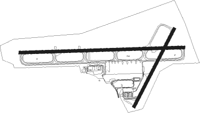
Runway info
Runway 10 / 28  | ||
| length | 2494m (8182ft) | |
| bearing | 92° / 272° | |
| width | 46m (150ft) | |
| surface | asphalt | |
| blast zone | 61m (200ft) / 61m (200ft) | |
| Runway 04 / 22 | ||
| length | 1327m (4354ft) | |
| bearing | 38° / 218° | |
| width | 46m (150ft) | |
| surface | asphalt | |
| displ threshold | 0m (0ft) / 19m (62ft) | |
| blast zone | 61m (200ft) / 0m (0ft) | |
Nearby beacons
| code | identifier | dist | bearing | frequency |
|---|---|---|---|---|
| GTC | NIIGATA VORTAC | 0.2 | 53° | 115.50 |
| YSE | SHONAI VOR/DME | 60.6 | 39° | 109.60 |
Departure and arrival routes
| Transition altitude | 14000ft |
| Transition level | 14000ft |
| SID end points | distance | outbound heading | |
|---|---|---|---|
| RW04 | |||
| KENSI6 | 50mi | 33° | |
| OKESA5 | 50mi | 219° | |
| KADBO6 | 100mi | 313° | |
| RW10 | |||
| SASAG2, KENSI6 | 50mi | 33° | |
| MOKBA1 | 27mi | 119° | |
| OKESA5 | 50mi | 219° | |
| KADBO6 | 100mi | 313° | |
| RW22 | |||
| KENSI6 | 50mi | 33° | |
| OKESA5 | 50mi | 219° | |
| KADBO6 | 100mi | 313° | |
| RW28 | |||
| KENSI6, SASAG2 | 50mi | 33° | |
| MOKBA1 | 27mi | 119° | |
| OKESA5 | 50mi | 219° | |
| KADBO6 | 100mi | 313° | |
| STAR starting points | distance | inbound heading | |
|---|---|---|---|
| RW10 | |||
| MAGNAW | 39.8 | 39° | |
| TERADW | 36.6 | 61° | |
| INAHOW | 13.2 | 204° | |
| GOSENW | 29.9 | 339° | |
| RW28 | |||
| MAGNAE | 39.8 | 39° | |
| TERADE | 36.6 | 61° | |
| INAHOE | 13.2 | 204° | |
| GOSENE | 29.9 | 339° | |
Instrument approach procedures
| runway | airway (heading) | route (dist, bearing) |
|---|---|---|
| RW10 | MOKBA (69°) | MOKBA 4000ft KODOH (6mi, 3°) 1700ft |
| RW10 | RYUTO (78°) | RYUTO 4000ft KODOH (6mi, 47°) 1700ft |
| RW10 | TOKKY (116°) | TOKKY 3000ft KODOH (6mi, 183°) 1700ft |
| RNAV | KODOH 1700ft YUJUN (5mi, 92°) 1700ft RJSN (6mi, 92°) 79ft (7603mi, 255°) 510ft INAHO (7599mi, 75°) 3000ft INAHO (turn) 3000ft |
Disclaimer
The information on this website is not for real aviation. Use this data with the X-Plane flight simulator only! Data taken with kind consent from X-Plane 12 source code and data files. Content is subject to change without notice.