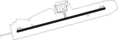
Shonai
Airport details
| Country | Japan |
| State | Yamagata Prefecture |
| Region | RJ |
| Airspace | Fukuoka Ctr |
| Municipality | Sakata |
| Elevation | 70ft (21m) |
| Timezone | GMT +9 |
| Coordinates | 38.81222, 139.78722 |
| Magnetic var | |
| Type | land |
| Available since | X-Plane v10.40 |
| ICAO code | RJSY |
| IATA code | SYO |
| FAA code | n/a |
Communication
| Shonai RDO | 126.200 |
| Shonai RDO | 118.800 |
| Shonai Tokyo Control | 132.300 |
| Shonai Tokyo Control | 135.900 |
Approach frequencies
| LOC | RW27 | 111.5 | 18.00mi |
| ILS-cat-I | RW09 | 110.9 | 18.00mi |
| 3° GS | RW09 | 110.9 | 18.00mi |
Nearby Points of Interest:
Three Mountains of Dewa
-Kisakata
Nearby beacons
| code | identifier | dist | bearing | frequency |
|---|---|---|---|---|
| YSE | SHONAI VOR/DME | 0.5 | 97° | 109.60 |
| YTE | YAMAGATA VOR/DME | 36.9 | 127° | 113 |
| UWE | YUWA (AKITA) VOR/DME | 51.7 | 26° | 110.65 |
| GTC | NIIGATA VORTAC | 60.2 | 218° | 115.50 |
Departure and arrival routes
| Transition altitude | 14000ft |
| Transition level | 14000ft |
| SID end points | distance | outbound heading | |
|---|---|---|---|
| RW09 | |||
| ZUNDA1 | 50mi | 134° | |
| RW27 | |||
| ZUNDA1 | 50mi | 134° | |
| STAR starting points | distance | inbound heading | |
|---|---|---|---|
| RW09 | |||
| YURAH | 24.1 | 306° | |
| RW27 | |||
| MOKKE | 24.1 | 306° | |
Instrument approach procedures
| runway | airway (heading) | route (dist, bearing) |
|---|---|---|
| RW09 | USUBA (306°) | USUBA 9000ft MOSSH (8mi, 295°) 7100ft |
| RNAV | MOSSH 7100ft SY954 (5mi, 295°) 5200ft SY955 (9mi, 295°) 2700ft SY956 (1mi, 295°) 2230ft SY957 (4mi, 13°) 669ft RJSY (2mi, 82°) 114ft SY958 (5mi, 82°) YSE (5mi, 260°) 4000ft YSE (turn) 4000ft | |
| RW27-Y | USUBA (306°) | USUBA 9000ft ANNON (7mi, 318°) 5400ft |
| RNAV | ANNON 5400ft SY754 (6mi, 318°) 4200ft SY755 (6mi, 318°) 2400ft SY756 (1mi, 318°) 1967ft SY757 (2mi, 288°) 1240ft RJSY (4mi, 262°) 136ft SY758 (turn) SY753 (2mi, 262°) YSE (3mi, 85°) 4000ft YSE (turn) 4000ft | |
| RW27-Z | MOKKE (282°) | MOKKE 3400ft SY752 (3mi, 308°) 2600ft MINAM (3mi, 308°) 1700ft |
| RNAV | MINAM 1700ft KYODN (3mi, 262°) 1090ft RJSY (4mi, 262°) 136ft SY753 (2mi, 262°) YSE (3mi, 85°) 4000ft YSE (turn) 4000ft |
Holding patterns
| STAR name | hold at | type | turn | heading* | altitude | leg | speed limit |
|---|---|---|---|---|---|---|---|
| YSE | YSE | NDB | right | 326 (146)° | > 4000ft | 1.0min timed | 230 |
| *) magnetic outbound (inbound) holding course | |||||||
Disclaimer
The information on this website is not for real aviation. Use this data with the X-Plane flight simulator only! Data taken with kind consent from X-Plane 12 source code and data files. Content is subject to change without notice.
