Tateyama
Airport details
| Country | Japan |
| State | Chiba Prefecture |
| Region | RJ |
| Airspace | Fukuoka Ctr |
| Municipality | Tateyama |
| Elevation | 8ft (2m) |
| Timezone | GMT +9 |
| Coordinates | 34.98682, 139.83380 |
| Magnetic var | |
| Type | land |
| Available since | X-Plane v10.40 |
| ICAO code | RJTE |
| IATA code | n/a |
| FAA code | n/a |
Communication
| Tateyama Tower | 122.000 |
| Tateyama Tower | 126.200 |
| Tateyama Tower | 123.100 |
| Tateyama TOKYO Approach | 119.100 |
| Tateyama TOKYO Departure | 126.000 |
Nearby Points of Interest:
Tateyama Bay
-Asaina Pass
-Kobukurozaka
-Kewaizaka
-Daibutsu Pass
-Garden of Engaku-ji
-Kanagawa Prefectural offices
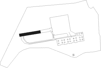
Runway info
| Runway 09 / 27 | ||
| length | 303m (994ft) | |
| bearing | 86° / 266° | |
| width | 45m (148ft) | |
| surface | concrete | |
Nearby beacons
| code | identifier | dist | bearing | frequency |
|---|---|---|---|---|
| TET | TATEYAMA TACAN | 0.9 | 165° | 108.80 |
| PQD | DME | 3.8 | 123° | 112.50 |
| HYD | DME | 20.1 | 317° | 116.20 |
| KZT | KISARAZU TACAN | 24.8 | 10° | 110.05 |
| OSE | MIHARA (OSHIMA) VOR/DME | 26 | 247° | 109.85 |
| XAC | OSHIMA VORTAC | 26.4 | 237° | 113.10 |
| OJT | ONJUKU TACAN | 28.9 | 70° | 115.70 |
| NJA | ATSUGI TACAN | 33.2 | 320° | 115.10 |
| HME | HANEDA (TOKYO) VOR/DME | 34.7 | 353° | 112.20 |
| NJT | NIIJIMA TACAN | 47.3 | 221° | 116.50 |
| TNT | TACHIKAWA TACAN | 48.7 | 329° | 115.80 |
| TN | SHIN-TACHIKAWA NDB | 48.8 | 329° | 366 |
| SHT | SHIMOFUSA (MATSUDO) TACAN | 49.7 | 12° | 108.20 |
| YOK | YOKOTA (TOKYO) TACAN | 51.5 | 328° | 113.80 |
| NRE | NARITA (TOKYO) VOR/DME | 54.3 | 34° | 117.90 |
| YLT | IRUMA TACAN | 55.1 | 334° | 110.60 |
| MOE | OYAMA VOR/DME | 56.6 | 197° | 108.65 |
| SND | (TOKYO) DME | 57.3 | 9° | 114 |
| CVT | CHOSHI TACAN | 64.9 | 53° | 113.60 |
Disclaimer
The information on this website is not for real aviation. Use this data with the X-Plane flight simulator only! Data taken with kind consent from X-Plane 12 source code and data files. Content is subject to change without notice.